South Chicago Heights geodata
South Chicago Heights (Illinois) is a populated place; located in United States in America/Chicago (GMT-5) time zone. With population of 4,138 people, there are 8057 cities with bigger population in this country. Compared to other cities in United States, 70.6% of cities are located further ↓South; 51.2% of cities are located further →East and 55.4% of cities have lower elevation than South Chicago Heights. Note1
Current local time in South Chicago Heights:
02:51 PM, WednesdayDifference from your time zone: hours


South Chicago Heights GPS coordinates[2]
41° 28' 51.132" North, 87° 38' 16.152" West
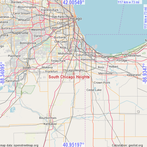
| Map corner | latitude | longitude |
|---|---|---|
| Upper-left | 42.00549°, | -88.34095° |
| Center: | 41.48087°, | -87.63782° |
| Lower-right: | 40.95197°, | -86.9347° |
| Map W x H: | 117.1×117.1 km | = 72.8×72.8mi |
| max Lat: | 71.29058° ⇑29.4% North |
| South Chicago Heights: | 41.48087° |
| min Lat: | ⇓70.6% South 19.06759° |
| min Long | South Chicago H | max Long |
| -171.73463° | -87.63782° | -66.98998° |
| W 48.8%⇐ | ⇒51.2% E |
Elevation
Elevation of South Chicago Heights is 220 m = 722 ft, and this is 74.8 m = 245 ft below average elevation for this country.
| Max E: |
3189 m = 10463 ft | 44.6% |
| Avg. | 294.8 m = 967 ft | |
| South Chicago Heights | 220 m = 722 ft | |
Min E: |
-60 m = -197 ft | 55.4% |
See also: United States elevation on elevation.city.
Geographical zone
South Chicago Heights is located in North temperate zone (between Tropic of Cancer and the Arctic Circle). Distance of this Northern Tropic circle is 2006.3 km =1246.7 mi to South.| Distance of | km | miles | from South Chicago Heights |
|---|---|---|---|
| North Pole | 5394.8 | 3352.2 | to North |
| Arctic Circle | 2788.9 | 1732.9 | to North |
| Tropic Cancer | 2006.3 | 1246.7 | to South |
| Equator | 4612.2 | 2865.9 | to South |


Nearby cities:
15 places around South Chicago Heights: (largest is in red/bold)
• Chicago Heights
2.8 km =1.7 mi,  3°
3°
• Crete
4.1 km =2.5 mi,  172°
172°
• Flossmoor
7.9 km =4.9 mi,  330°
330°
• Ford Heights
4.8 km =3 mi,  53°
53°
• Glenwood
7.5 km =4.7 mi,  23°
23°
• Homewood
8.8 km =5.5 mi,  344°
344°
• Lynwood
9.7 km =6 mi,  58°
58°
• Matteson
6.8 km =4.2 mi,  292°
292°
• Olympia Fields
4.7 km =2.9 mi,  320°
320°
• Park Forest
3.3 km =2.1 mi, 291°
• Richton Park
5.5 km =3.4 mi,  274°
274°
• Sauk Village
5.9 km =3.7 mi,  81°
81°
• Steger
1.2 km =0.7 mi, 174°
• University Park
5.7 km =3.5 mi,  222°
222°
• Willowbrook
8.8 km =5.5 mi,  106°
106°
Sources, notices
• [Note1] Compared only with cities in United States existing in our database
• [Src1] Map data: © OpenStreetMap contributors (CC-BY-SA)
• [Src2] Other city data from geonames.org with taken over terms of usage.
• [Src3] Geographical zone / Annual Mean Temperature by Robert A. Rohde @ Wikipedia
