Spring Valley geodata
Spring Valley (Illinois) is a populated place; located in United States in America/Chicago (GMT-5) time zone. With population of 5,314 people, there are 6898 cities with bigger population in this country. Compared to other cities in United States, 69.1% of cities are located further ↓South; 56.7% of cities are located further →East and 54.2% of cities have higher elevation than Spring Valley. Note1


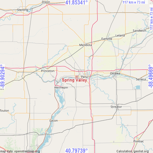
Spring Valley GPS coordinates[2]
41° 19' 39.144" North, 89° 11' 59.316" West
| Map corner | latitude | longitude |
|---|---|---|
| Upper-left | 41.85341°, | -89.90294° |
| Center: | 41.32754°, | -89.19981° |
| Lower-right: | 40.79739°, | -88.49669° |
| Map W x H: | 117.4×117.4 km | = 72.9×72.9mi |
| max Lat: | 71.29058° ⇑30.9% North |
| Spring Valley: | 41.32754° |
| min Lat: | ⇓69.1% South 19.06759° |
| min Long | Spring Valley | max Long |
| -171.73463° | -89.19981° | -66.98998° |
| W 43.3%⇐ | ⇒56.7% E |
Elevation
Elevation of Spring Valley is 183 m = 600 ft, and this is 111.8 m = 367 ft below average elevation for this country.
| Max E: |
3189 m = 10463 ft | 54.2% |
| Avg. | 294.8 m = 967 ft | |
| Spring Valley | 183 m = 600 ft | |
Min E: |
-60 m = -197 ft | 45.8% |
See also: United States elevation on elevation.city.
Geographical zone
Spring Valley is located in North temperate zone (between Tropic of Cancer and the Arctic Circle). Distance of this Northern Tropic circle is 1989.3 km =1236.1 mi to South.| Distance of | km | miles | from Spring Valley |
|---|---|---|---|
| North Pole | 5411.9 | 3362.8 | to North |
| Arctic Circle | 2806 | 1743.6 | to North |
| Tropic Cancer | 1989.3 | 1236.1 | to South |
| Equator | 4595.2 | 2855.3 | to South |


Nearby cities:
15 places around Spring Valley: (largest is in red/bold)
• Dalzell
3.9 km =2.4 mi,  30°
30°
• Deer Park
14.1 km =8.8 mi,  104°
104°
• Depue
8.9 km =5.5 mi,  267°
267°
• Granville
7.7 km =4.8 mi,  197°
197°
• Hennepin
14.4 km =8.9 mi,  235°
235°
• La Moille
23.7 km =14.7 mi,  343°
343°
• La Salle
9 km =5.6 mi,  85°
85°
• Ladd
6.3 km =3.9 mi,  345°
345°
• Mark
8.2 km =5.1 mi,  210°
210°
• Mendota
25.4 km =15.8 mi,  15°
15°
• Oglesby
12.3 km =7.6 mi,  107°
107°
• Peru
5.9 km =3.7 mi, 90°
• Princeton
22.6 km =14 mi,  281°
281°
• Tonica
16.7 km =10.4 mi,  138°
138°
• Utica
15.9 km =9.9 mi,  84°
84°
Sources, notices
• [Note1] Compared only with cities in United States existing in our database
• [Src1] Map data: © OpenStreetMap contributors (CC-BY-SA)
• [Src2] Other city data from geonames.org with taken over terms of usage.
• [Src3] Geographical zone / Annual Mean Temperature by Robert A. Rohde @ Wikipedia
