Tremont geodata
Tremont (Illinois) is a populated place; located in United States in America/Chicago (GMT-5) time zone. With population of 2,175 people, there are 11403 cities with bigger population in this country. Compared to other cities in United States, 59.2% of cities are located further ↓South; 57.5% of cities are located further →East and 50.2% of cities have lower elevation than Tremont. Note1


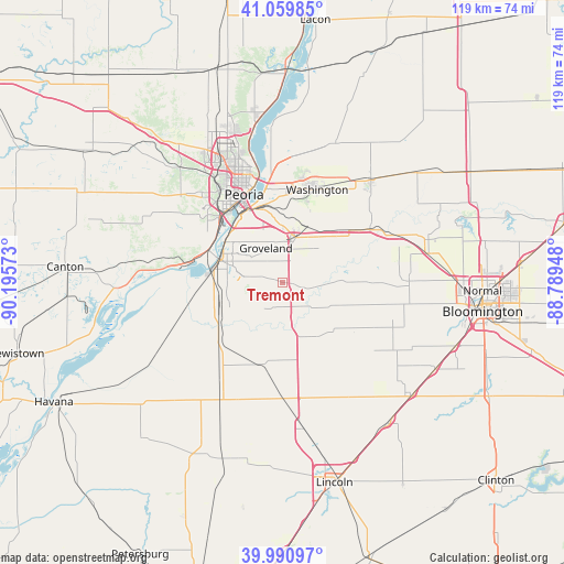
Tremont GPS coordinates[2]
40° 31' 39.144" North, 89° 29' 33.36" West
| Map corner | latitude | longitude |
|---|---|---|
| Upper-left | 41.05985°, | -90.19573° |
| Center: | 40.52754°, | -89.4926° |
| Lower-right: | 39.99097°, | -88.78948° |
| Map W x H: | 118.8×118.8 km | = 73.8×73.8mi |
| max Lat: | 71.29058° ⇑40.8% North |
| Tremont: | 40.52754° |
| min Lat: | ⇓59.2% South 19.06759° |
| min Long | Tremont | max Long |
| -171.73463° | -89.4926° | -66.98998° |
| W 42.5%⇐ | ⇒57.5% E |
Elevation
Elevation of Tremont is 199 m = 653 ft, and this is 95.8 m = 314 ft below average elevation for this country.
| Max E: |
3189 m = 10463 ft | 49.8% |
| Avg. | 294.8 m = 967 ft | |
| Tremont | 199 m = 653 ft | |
Min E: |
-60 m = -197 ft | 50.2% |
See also: United States elevation on elevation.city.
Geographical zone
Tremont is located in North temperate zone (between Tropic of Cancer and the Arctic Circle). Distance of this Northern Tropic circle is 1900.3 km =1180.8 mi to South.| Distance of | km | miles | from Tremont |
|---|---|---|---|
| North Pole | 5500.8 | 3418 | to North |
| Arctic Circle | 2894.9 | 1798.8 | to North |
| Tropic Cancer | 1900.3 | 1180.8 | to South |
| Equator | 4506.2 | 2800 | to South |


Nearby cities:
15 places around Tremont: (largest is in red/bold)
• Bartonville
19.2 km =11.9 mi,  315°
315°
• Creve Coeur
15.7 km =9.8 mi,  327°
327°
• Deer Creek
17.7 km =11 mi,  49°
49°
• Delavan
17.8 km =11.1 mi,  195°
195°
• East Peoria
17.1 km =10.6 mi, 334°
• Green Valley
18.4 km =11.4 mi,  223°
223°
• Heritage Lake
14.3 km =8.9 mi,  81°
81°
• Hopedale
13.6 km =8.5 mi,  150°
150°
• Mackinaw
11.5 km =7.1 mi, 84°
• Marquette Heights
13.5 km =8.4 mi, 317°
• Minier
18.4 km =11.4 mi,  124°
124°
• Morton
9.9 km =6.2 mi,  16°
16°
• North Pekin
14.7 km =9.1 mi,  311°
311°
• Pekin
13.3 km =8.3 mi,  289°
289°
• South Pekin
13.9 km =8.6 mi,  254°
254°
Sources, notices
• [Note1] Compared only with cities in United States existing in our database
• [Src1] Map data: © OpenStreetMap contributors (CC-BY-SA)
• [Src2] Other city data from geonames.org with taken over terms of usage.
• [Src3] Geographical zone / Annual Mean Temperature by Robert A. Rohde @ Wikipedia
