Town of Pines geodata
Town of Pines (Indiana) is a populated place; located in United States in America/Chicago (GMT-5) time zone. With population of 706 people, there are 18614 cities with bigger population in this country. Compared to other cities in United States, 72.7% of cities are located further ↓South; 50.4% of cities are located further ←West and 51.4% of cities have higher elevation than Town of Pines. Note1


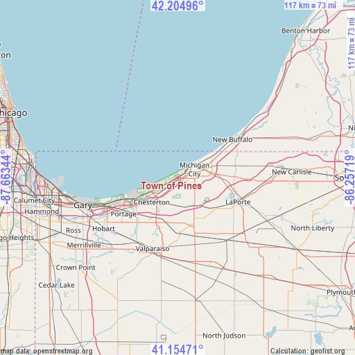
Town of Pines GPS coordinates[2]
41° 40' 55.128" North, 86° 57' 37.116" West
| Map corner | latitude | longitude |
|---|---|---|
| Upper-left | 42.20496°, | -87.66344° |
| Center: | 41.68198°, | -86.96031° |
| Lower-right: | 41.15471°, | -86.25719° |
| Map W x H: | 116.8×116.8 km | = 72.6×72.6mi |
| max Lat: | 71.29058° ⇑27.3% North |
| Town of Pines: | 41.68198° |
| min Lat: | ⇓72.7% South 19.06759° |
| min Long | Town of Pines | max Long |
| -171.73463° | -86.96031° | -66.98998° |
| W 50.4%⇐ | ⇒49.6% E |
Elevation
Elevation of Town of Pines is 193 m = 633 ft, and this is 101.8 m = 334 ft below average elevation for this country.
| Max E: |
3189 m = 10463 ft | 51.4% |
| Avg. | 294.8 m = 967 ft | |
| Town of Pines | 193 m = 633 ft | |
Min E: |
-60 m = -197 ft | 48.6% |
See also: United States elevation on elevation.city.
Geographical zone
Town of Pines is located in North temperate zone (between Tropic of Cancer and the Arctic Circle). Distance of this Northern Tropic circle is 2028.7 km =1260.6 mi to South.| Distance of | km | miles | from Town of Pines |
|---|---|---|---|
| North Pole | 5372.5 | 3338.3 | to North |
| Arctic Circle | 2766.6 | 1719.1 | to North |
| Tropic Cancer | 2028.7 | 1260.6 | to South |
| Equator | 4634.6 | 2879.8 | to South |


Nearby cities:
15 places around Town of Pines: (largest is in red/bold)
• Beverly Shores
1.9 km =1.2 mi,  309°
309°
• Burns Harbor
15.7 km =9.8 mi,  246°
246°
• Chesterton
11.7 km =7.3 mi,  227°
227°
• La Porte
22.1 km =13.7 mi,  111°
111°
• LaPorte
21.3 km =13.2 mi, 111°
• Long Beach
10.7 km =6.6 mi,  53°
53°
• Michigan City
6.1 km =3.8 mi,  62°
62°
• New Buffalo
21.8 km =13.5 mi, 55°
• Ogden Dunes
20.3 km =12.6 mi, 251°
• Portage
21.5 km =13.4 mi,  236°
236°
• Porter
12 km =7.5 mi, 232°
• South Haven
21.4 km =13.3 mi,  223°
223°
• Trail Creek
8.6 km =5.3 mi,  77°
77°
• Valparaiso
24.7 km =15.3 mi,  199°
199°
• Westville
16.4 km =10.2 mi,  162°
162°
Sources, notices
• [Note1] Compared only with cities in United States existing in our database
• [Src1] Map data: © OpenStreetMap contributors (CC-BY-SA)
• [Src2] Other city data from geonames.org with taken over terms of usage.
• [Src3] Geographical zone / Annual Mean Temperature by Robert A. Rohde @ Wikipedia
