Douglas geodata
Douglas (Massachusetts) is a populated place; located in United States in America/New_York (GMT-4) time zone. With population of 7,168 people, there are 5718 cities with bigger population in this country. Compared to other cities in United States, 76.1% of cities are located further ↓South; 96.1% of cities are located further ←West and 55.3% of cities have higher elevation than Douglas. Note1
Administrative division(s):
- Level 1: Massachusetts
- Level 2: Worcester County
- Level 3: Town of Douglas


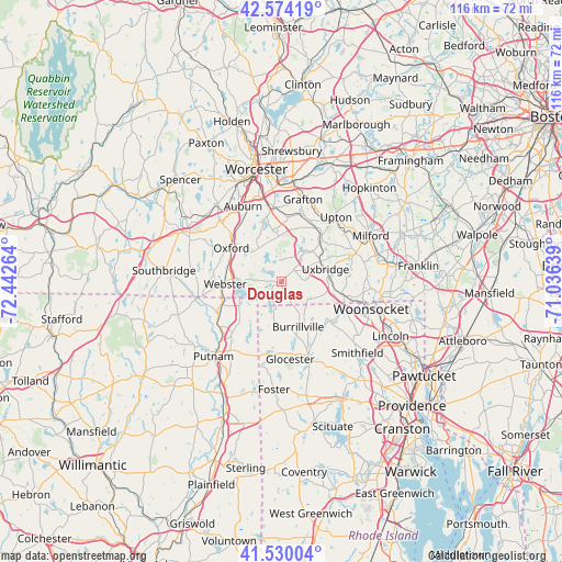
Douglas GPS coordinates[2]
42° 3' 15.336" North, 71° 44' 22.236" West
| Map corner | latitude | longitude |
|---|---|---|
| Upper-left | 42.57419°, | -72.44264° |
| Center: | 42.05426°, | -71.73951° |
| Lower-right: | 41.53004°, | -71.03639° |
| Map W x H: | 116.1×116.1 km | = 72.1×72.1mi |
| max Lat: | 71.29058° ⇑23.9% North |
| Douglas: | 42.05426° |
| min Lat: | ⇓76.1% South 19.06759° |
| min Long | Douglas | max Long |
| -171.73463° | -71.73951° | -66.98998° |
| W 96.1%⇐ | ⇒3.9% E |
Elevation
Elevation of Douglas is 179 m = 587 ft, and this is 115.8 m = 380 ft below average elevation for this country.
| Max E: |
3189 m = 10463 ft | 55.3% |
| Avg. | 294.8 m = 967 ft | |
| Douglas | 179 m = 587 ft | |
Min E: |
-60 m = -197 ft | 44.7% |
See also: United States elevation on elevation.city.
Geographical zone
Douglas is located in North temperate zone (between Tropic of Cancer and the Arctic Circle). Distance of this Northern Tropic circle is 2070.1 km =1286.3 mi to South.| Distance of | km | miles | from Douglas |
|---|---|---|---|
| North Pole | 5331.1 | 3312.6 | to North |
| Arctic Circle | 2725.2 | 1693.4 | to North |
| Tropic Cancer | 2070.1 | 1286.3 | to South |
| Equator | 4676 | 2905.5 | to South |


Nearby cities:
15 places around Douglas: (largest is in red/bold)
• Dudley
15.8 km =9.8 mi,  266°
266°
• East Douglas
2.9 km =1.8 mi,  47°
47°
• Harrisville
11.2 km =7 mi,  151°
151°
• Mendon
16.5 km =10.3 mi,  69°
69°
• Millbury
15.6 km =9.7 mi,  353°
353°
• Millville
13.4 km =8.3 mi,  102°
102°
• North Grosvenor Dale
15.2 km =9.4 mi,  239°
239°
• Northbridge
13.1 km =8.1 mi,  34°
34°
• Oxford
12.5 km =7.8 mi,  303°
303°
• Pascoag
11.4 km =7.1 mi,  164°
164°
• Sutton
10.8 km =6.7 mi, 349°
• Thompson
14.7 km =9.1 mi,  223°
223°
• Uxbridge
9.4 km =5.8 mi, 74°
• Webster
11.6 km =7.2 mi, 267°
• Whitinsville
8.8 km =5.5 mi,  43°
43°
Sources, notices
• [Note1] Compared only with cities in United States existing in our database
• [Src1] Map data: © OpenStreetMap contributors (CC-BY-SA)
• [Src2] Other city data from geonames.org with taken over terms of usage.
• [Src3] Geographical zone / Annual Mean Temperature by Robert A. Rohde @ Wikipedia
