Shutesbury geodata
Shutesbury (Massachusetts) is a populated place; located in United States in America/New_York (GMT-4) time zone. With population of 1,842 people, there are 12403 cities with bigger population in this country. Compared to other cities in United States, 79.4% of cities are located further ↓South; 95% of cities are located further ←West and 82.3% of cities have lower elevation than Shutesbury. Note1
Administrative division(s):
- Level 1: Massachusetts
- Level 2: Franklin County
- Level 3: Town of Shutesbury


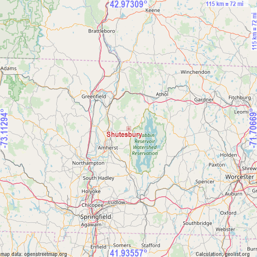
Shutesbury GPS coordinates[2]
42° 27' 23.328" North, 72° 24' 35.316" West
| Map corner | latitude | longitude |
|---|---|---|
| Upper-left | 42.97309°, | -73.11294° |
| Center: | 42.45648°, | -72.40981° |
| Lower-right: | 41.93557°, | -71.70669° |
| Map W x H: | 115.4×115.4 km | = 71.7×71.7mi |
| max Lat: | 71.29058° ⇑20.6% North |
| Shutesbury: | 42.45648° |
| min Lat: | ⇓79.4% South 19.06759° |
| min Long | Shutesbury | max Long |
| -171.73463° | -72.40981° | -66.98998° |
| W 95%⇐ | ⇒5% E |
Elevation
Elevation of Shutesbury is 380 m = 1247 ft, and this is 85.2 m = 280 ft above average elevation for this country.
| Max E: |
3189 m = 10463 ft | 17.7% |
| Shutesbury | 380 m 1247 ft | |
| Avg. | 294.8 m = 967 ft | |
Min E: |
-60 m = -197 ft | 82.3% |
See also: United States elevation on elevation.city.
Geographical zone
Shutesbury is located in North temperate zone (between Tropic of Cancer and the Arctic Circle). Distance of this Northern Tropic circle is 2114.8 km =1314.1 mi to South.| Distance of | km | miles | from Shutesbury |
|---|---|---|---|
| North Pole | 5286.3 | 3284.8 | to North |
| Arctic Circle | 2680.5 | 1665.6 | to North |
| Tropic Cancer | 2114.8 | 1314.1 | to South |
| Equator | 4720.7 | 2933.3 | to South |


Nearby cities:
15 places around Shutesbury: (largest is in red/bold)
• Amherst
13.3 km =8.3 mi,  221°
221°
• Amherst Center
12.7 km =7.9 mi, 224°
• Erving
16 km =9.9 mi,  3°
3°
• Hatfield
18.2 km =11.3 mi,  238°
238°
• Leverett
7.5 km =4.7 mi,  266°
266°
• Millers Falls
15.5 km =9.6 mi,  334°
334°
• Montague
13.5 km =8.4 mi,  310°
310°
• New Salem
8.3 km =5.2 mi,  50°
50°
• North Amherst
11.2 km =7 mi, 242°
• Orange
17 km =10.6 mi,  28°
28°
• Pelham
7.1 km =4.4 mi,  175°
175°
• South Amherst
15.1 km =9.4 mi,  211°
211°
• South Deerfield
16.4 km =10.2 mi,  278°
278°
• Wendell
10.2 km =6.3 mi,  5°
5°
• Whately
18.6 km =11.6 mi,  264°
264°
Sources, notices
• [Note1] Compared only with cities in United States existing in our database
• [Src1] Map data: © OpenStreetMap contributors (CC-BY-SA)
• [Src2] Other city data from geonames.org with taken over terms of usage.
• [Src3] Geographical zone / Annual Mean Temperature by Robert A. Rohde @ Wikipedia
