Weweantic geodata
Weweantic (Massachusetts) is a populated place; located in United States in America/New_York (GMT-4) time zone. With population of 2,105 people, there are 11604 cities with bigger population in this country. Compared to other cities in United States, 73.3% of cities are located further ↓South; 98.1% of cities are located further ←West and 95.7% of cities have higher elevation than Weweantic. Note1
Administrative division(s):
- Level 1: Massachusetts
- Level 2: Plymouth County
- Level 3: Town of Wareham


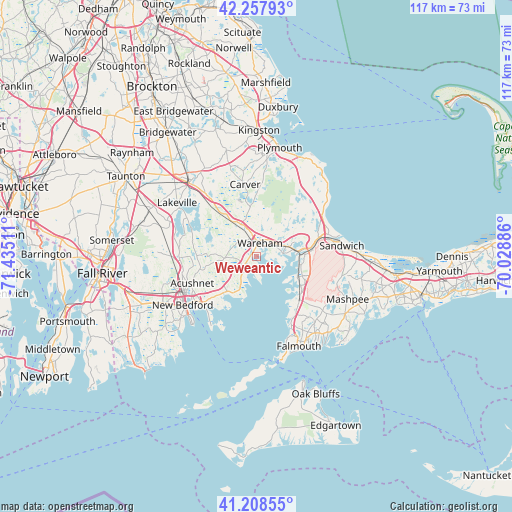
Weweantic GPS coordinates[2]
41° 44' 7.368" North, 70° 43' 55.128" West
| Map corner | latitude | longitude |
|---|---|---|
| Upper-left | 42.25793°, | -71.43511° |
| Center: | 41.73538°, | -70.73198° |
| Lower-right: | 41.20855°, | -70.02886° |
| Map W x H: | 116.7×116.7 km | = 72.5×72.5mi |
| max Lat: | 71.29058° ⇑26.7% North |
| Weweantic: | 41.73538° |
| min Lat: | ⇓73.3% South 19.06759° |
| min Long | Weweantic | max Long |
| -171.73463° | -70.73198° | -66.98998° |
| W 98.1%⇐ | ⇒1.9% E |
Elevation
Elevation of Weweantic is 8 m = 26 ft, and this is 286.8 m = 941 ft below average elevation for this country.
| Max E: |
3189 m = 10463 ft | 95.7% |
| Avg. | 294.8 m = 967 ft | |
| Weweantic | 8 m = 26 ft | |
Min E: |
-60 m = -197 ft | 4.3% |
See also: United States elevation on elevation.city.
Geographical zone
Weweantic is located in North temperate zone (between Tropic of Cancer and the Arctic Circle). Distance of this Northern Tropic circle is 2034.6 km =1264.2 mi to South.| Distance of | km | miles | from Weweantic |
|---|---|---|---|
| North Pole | 5366.5 | 3334.6 | to North |
| Arctic Circle | 2760.6 | 1715.4 | to North |
| Tropic Cancer | 2034.6 | 1264.2 | to South |
| Equator | 4640.5 | 2883.5 | to South |


Nearby cities:
15 places around Weweantic: (largest is in red/bold)
• Acushnet Center
15.5 km =9.6 mi,  248°
248°
• Bourne
11.1 km =6.9 mi,  86°
86°
• Buzzards Bay
9.5 km =5.9 mi,  83°
83°
• Marion
4.7 km =2.9 mi,  213°
213°
• Marion Center
4.3 km =2.7 mi,  216°
216°
• Mattapoisett
11 km =6.8 mi, 219°
• Mattapoisett Center
9.9 km =6.2 mi, 218°
• Monument Beach
10.1 km =6.3 mi,  100°
100°
• North Falmouth
13.7 km =8.5 mi,  136°
136°
• Onset
6.2 km =3.9 mi, 83°
• Pocasset
11.1 km =6.9 mi,  119°
119°
• Rochester
7.3 km =4.5 mi,  266°
266°
• Wareham Center
3.5 km =2.2 mi,  7°
7°
• West Wareham
6.5 km =4 mi,  338°
338°
• White Island Shores
10.8 km =6.7 mi,  48°
48°
Sources, notices
• [Note1] Compared only with cities in United States existing in our database
• [Src1] Map data: © OpenStreetMap contributors (CC-BY-SA)
• [Src2] Other city data from geonames.org with taken over terms of usage.
• [Src3] Geographical zone / Annual Mean Temperature by Robert A. Rohde @ Wikipedia
