Ellsworth geodata
Ellsworth (Maine) is a seat of a second-order administrative division; located in United States in America/New_York (GMT-4) time zone. With population of 7,857 people, there are 5351 cities with bigger population in this country. Compared to other cities in United States, 90.7% of cities are located further ↓South; 99.7% of cities are located further ←West and 83.2% of cities have higher elevation than Ellsworth. Note1


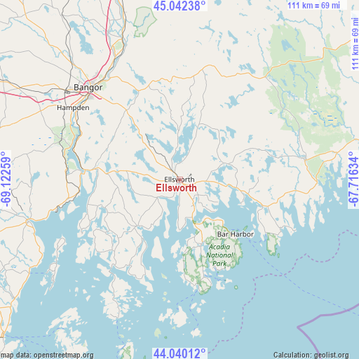
Ellsworth GPS coordinates[2]
44° 32' 36.276" North, 68° 25' 10.056" West
| Map corner | latitude | longitude |
|---|---|---|
| Upper-left | 45.04238°, | -69.12259° |
| Center: | 44.54341°, | -68.41946° |
| Lower-right: | 44.04012°, | -67.71634° |
| Map W x H: | 111.4×111.4 km | = 69.2×69.2mi |
| max Lat: | 71.29058° ⇑9.3% North |
| Ellsworth: | 44.54341° |
| min Lat: | ⇓90.7% South 19.06759° |
| min Long | Ellsworth | max Long |
| -171.73463° | -68.41946° | -66.98998° |
| W 99.7%⇐ | ⇒0.3% E |
Elevation
Elevation of Ellsworth is 34 m = 112 ft, and this is 260.8 m = 856 ft below average elevation for this country.
| Max E: |
3189 m = 10463 ft | 83.2% |
| Avg. | 294.8 m = 967 ft | |
| Ellsworth | 34 m = 112 ft | |
Min E: |
-60 m = -197 ft | 16.8% |
See also: United States elevation on elevation.city.
Geographical zone
Ellsworth is located in North temperate zone (between Tropic of Cancer and the Arctic Circle). Distance of this Northern Tropic circle is 2346.8 km =1458.2 mi to South.| Distance of | km | miles | from Ellsworth |
|---|---|---|---|
| North Pole | 5054.3 | 3140.6 | to North |
| Arctic Circle | 2448.4 | 1521.4 | to North |
| Tropic Cancer | 2346.8 | 1458.2 | to South |
| Equator | 4952.8 | 3077.5 | to South |


Nearby cities:
15 places around Ellsworth: (largest is in red/bold)
• Bar Harbor
24.3 km =15.1 mi,  135°
135°
• Blue Hill
19.6 km =12.2 mi,  222°
222°
• Brooksville
30.3 km =18.8 mi, 223°
• Bucksport
30 km =18.6 mi,  276°
276°
• Dedham
25.3 km =15.7 mi,  310°
310°
• Franklin
15.6 km =9.7 mi,  71°
71°
• Hancock
13.2 km =8.2 mi,  96°
96°
• Orland
25.2 km =15.7 mi, 276°
• Otis
19 km =11.8 mi,  352°
352°
• Penobscot
24.7 km =15.3 mi,  249°
249°
• Southwest Harbor
30.3 km =18.8 mi,  165°
165°
• Sullivan
17.8 km =11.1 mi, 98°
• Surry
8.4 km =5.2 mi,  230°
230°
• Trenton
12.3 km =7.6 mi,  161°
161°
• Verona
29.5 km =18.3 mi,  274°
274°
Sources, notices
• [Note1] Compared only with cities in United States existing in our database
• [Src1] Map data: © OpenStreetMap contributors (CC-BY-SA)
• [Src2] Other city data from geonames.org with taken over terms of usage.
• [Src3] Geographical zone / Annual Mean Temperature by Robert A. Rohde @ Wikipedia
