Saint Agatha geodata
Saint Agatha (Maine) is a populated place; located in United States in America/New_York (GMT-4) time zone. With population of 834 people, there are 17494 cities with bigger population in this country. Compared to other cities in United States, 97.1% of cities are located further ↓South; 99.8% of cities are located further ←West and 50.2% of cities have lower elevation than Saint Agatha. Note1


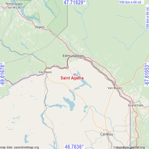
Saint Agatha GPS coordinates[2]
47° 14' 35.16" North, 68° 18' 49.14" West
| Map corner | latitude | longitude |
|---|---|---|
| Upper-left | 47.71829°, | -69.01678° |
| Center: | 47.2431°, | -68.31365° |
| Lower-right: | 46.7636°, | -67.61053° |
| Map W x H: | 106.2×106.1 km | = 66×65.9mi |
| max Lat: | 71.29058° ⇑2.9% North |
| Saint Agatha: | 47.2431° |
| min Lat: | ⇓97.1% South 19.06759° |
| min Long | Saint Agatha | max Long |
| -171.73463° | -68.31365° | -66.98998° |
| W 99.8%⇐ | ⇒0.2% E |
Elevation
Elevation of Saint Agatha is 199 m = 653 ft, and this is 95.8 m = 314 ft below average elevation for this country.
| Max E: |
3189 m = 10463 ft | 49.8% |
| Avg. | 294.8 m = 967 ft | |
| Saint Agatha | 199 m = 653 ft | |
Min E: |
-60 m = -197 ft | 50.2% |
See also: United States elevation on elevation.city.
Geographical zone
Saint Agatha is located in North temperate zone (between Tropic of Cancer and the Arctic Circle). Distance of this North polar circle is 2148.2 km =1334.8 mi to North.| Distance of | km | miles | from Saint Agatha |
|---|---|---|---|
| North Pole | 4754.1 | 2954.1 | to North |
| Arctic Circle | 2148.2 | 1334.8 | to North |
| Tropic Cancer | 2647 | 1644.8 | to South |
| Equator | 5252.9 | 3264 | to South |


Nearby cities:
15 places around Saint Agatha: (largest is in red/bold)
• Caribou
48.3 km =30 mi,  151°
151°
• Eagle Lake
30.7 km =19.1 mi,  222°
222°
• Fort Fairfield
63.7 km =39.6 mi, 145°
• Fort Kent
20.9 km =13 mi,  274°
274°
• Frenchville
6.5 km =4 mi,  310°
310°
• Grand Isle
14 km =8.7 mi,  60°
60°
• Limestone
52.4 km =32.6 mi,  135°
135°
• Madawaska
12.5 km =7.8 mi,  357°
357°
• Madawaska
48.6 km =30.2 mi, 145°
• Mapleton
63.4 km =39.4 mi,  169°
169°
• New Sweden Station
36 km =22.4 mi, 153°
• Saint Francis
44.2 km =27.5 mi,  259°
259°
• Van Buren
30.1 km =18.7 mi,  108°
108°
• Wallagrass
24.9 km =15.5 mi,  239°
239°
• Washburn
51.7 km =32.1 mi, 166°
Sources, notices
• [Note1] Compared only with cities in United States existing in our database
• [Src1] Map data: © OpenStreetMap contributors (CC-BY-SA)
• [Src2] Other city data from geonames.org with taken over terms of usage.
• [Src3] Geographical zone / Annual Mean Temperature by Robert A. Rohde @ Wikipedia
