Blaine geodata
Blaine (Minnesota) is a populated place; located in United States in America/Chicago (GMT-5) time zone. With population of 62,124 people, there are 708 cities with bigger population in this country. Compared to other cities in United States, 93.1% of cities are located further ↓South; 66.8% of cities are located further →East and 67.4% of cities have lower elevation than Blaine. Note1


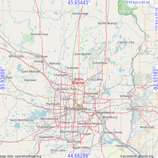
Blaine GPS coordinates[2]
45° 9' 38.88" North, 93° 14' 5.82" West
| Map corner | latitude | longitude |
|---|---|---|
| Upper-left | 45.65443°, | -93.93808° |
| Center: | 45.1608°, | -93.23495° |
| Lower-right: | 44.66286°, | -92.53183° |
| Map W x H: | 110.3×110.3 km | = 68.5×68.5mi |
| max Lat: | 71.29058° ⇑6.9% North |
| Blaine: | 45.1608° |
| min Lat: | ⇓93.1% South 19.06759° |
| min Long | Blaine | max Long |
| -171.73463° | -93.23495° | -66.98998° |
| W 33.2%⇐ | ⇒66.8% E |
Elevation
Elevation of Blaine is 273 m = 896 ft, and this is 21.8 m = 72 ft below average elevation for this country.
| Max E: |
3189 m = 10463 ft | 32.6% |
| Avg. | 294.8 m = 967 ft | |
| Blaine | 273 m = 896 ft | |
Min E: |
-60 m = -197 ft | 67.4% |
See also: Blaine elevation on elevation.city.
Geographical zone
Blaine is located in North temperate zone (between Tropic of Cancer and the Arctic Circle). Distance of this North polar circle is 2379.8 km =1478.7 mi to North.| Distance of | km | miles | from Blaine |
|---|---|---|---|
| North Pole | 4985.7 | 3098 | to North |
| Arctic Circle | 2379.8 | 1478.7 | to North |
| Tropic Cancer | 2415.5 | 1500.9 | to South |
| Equator | 5021.4 | 3120.2 | to South |


Nearby cities:
15 places around Blaine: (largest is in red/bold)
• Andover
9.2 km =5.7 mi,  331°
331°
• Brooklyn Center
12.1 km =7.5 mi,  219°
219°
• Brooklyn Park
12.1 km =7.5 mi,  232°
232°
• Circle Pines
6.7 km =4.2 mi,  101°
101°
• Coon Rapids
6.1 km =3.8 mi, 222°
• Fridley
8.6 km =5.3 mi,  194°
194°
• Ham Lake
10 km =6.2 mi,  353°
353°
• Hilltop
12 km =7.5 mi,  184°
184°
• Lexington
6 km =3.7 mi,  109°
109°
• Lino Lakes
11.5 km =7.1 mi,  90°
90°
• Mounds View
6.5 km =4 mi,  161°
161°
• New Brighton
10.9 km =6.8 mi,  166°
166°
• Shoreview
11.4 km =7.1 mi,  142°
142°
• Spring Lake Park
5.9 km =3.7 mi, 182°
• West Coon Rapids
9 km =5.6 mi,  269°
269°
Sources, notices
• [Note1] Compared only with cities in United States existing in our database
• [Src1] Map data: © OpenStreetMap contributors (CC-BY-SA)
• [Src2] Other city data from geonames.org with taken over terms of usage.
• [Src3] Geographical zone / Annual Mean Temperature by Robert A. Rohde @ Wikipedia
