Cokato geodata
Cokato (Minnesota) is a populated place; located in United States in America/Chicago (GMT-5) time zone. With population of 2,727 people, there are 10128 cities with bigger population in this country. Compared to other cities in United States, 92.9% of cities are located further ↓South; 69.1% of cities are located further →East and 76.8% of cities have lower elevation than Cokato. Note1


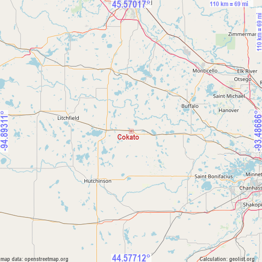
Cokato GPS coordinates[2]
45° 4' 32.88" North, 94° 11' 23.928" West
| Map corner | latitude | longitude |
|---|---|---|
| Upper-left | 45.57017°, | -94.89311° |
| Center: | 45.0758°, | -94.18998° |
| Lower-right: | 44.57712°, | -93.48686° |
| Map W x H: | 110.4×110.4 km | = 68.6×68.6mi |
| max Lat: | 71.29058° ⇑7.1% North |
| Cokato: | 45.0758° |
| min Lat: | ⇓92.9% South 19.06759° |
| min Long | Cokato | max Long |
| -171.73463° | -94.18998° | -66.98998° |
| W 30.9%⇐ | ⇒69.1% E |
Elevation
Elevation of Cokato is 326 m = 1070 ft, and this is 31.2 m = 102 ft above average elevation for this country.
| Max E: |
3189 m = 10463 ft | 23.2% |
| Cokato | 326 m 1070 ft | |
| Avg. | 294.8 m = 967 ft | |
Min E: |
-60 m = -197 ft | 76.8% |
See also: United States elevation on elevation.city.
Geographical zone
Cokato is located in North temperate zone (between Tropic of Cancer and the Arctic Circle). Distance of this North polar circle is 2389.2 km =1484.6 mi to North.| Distance of | km | miles | from Cokato |
|---|---|---|---|
| North Pole | 4995.1 | 3103.8 | to North |
| Arctic Circle | 2389.2 | 1484.6 | to North |
| Tropic Cancer | 2406 | 1495 | to South |
| Equator | 5012 | 3114.3 | to South |


Nearby cities:
15 places around Cokato: (largest is in red/bold)
• Annandale
21.4 km =13.3 mi,  13°
13°
• Buffalo
26.9 km =16.7 mi,  66°
66°
• Dassel
9.2 km =5.7 mi,  274°
274°
• Delano
31.7 km =19.7 mi,  96°
96°
• Howard Lake
9.3 km =5.8 mi, 100°
• Hutchinson
25.2 km =15.7 mi,  214°
214°
• Kimball
27.7 km =17.2 mi,  341°
341°
• Lester Prairie
24.3 km =15.1 mi,  151°
151°
• Litchfield
27.1 km =16.8 mi,  282°
282°
• Maple Lake
22.5 km =14 mi,  40°
40°
• Montrose
21.9 km =13.6 mi,  93°
93°
• Silver Lake
19.2 km =11.9 mi,  181°
181°
• Watertown
29.7 km =18.5 mi,  114°
114°
• Waverly
17.6 km =10.9 mi, 93°
• Winsted
16.7 km =10.4 mi,  138°
138°
Sources, notices
• [Note1] Compared only with cities in United States existing in our database
• [Src1] Map data: © OpenStreetMap contributors (CC-BY-SA)
• [Src2] Other city data from geonames.org with taken over terms of usage.
• [Src3] Geographical zone / Annual Mean Temperature by Robert A. Rohde @ Wikipedia
