Columbia Heights geodata
Columbia Heights (Minnesota) is a populated place; located in United States in America/Chicago (GMT-5) time zone. With population of 19,715 people, there are 2554 cities with bigger population in this country. Compared to other cities in United States, 92.7% of cities are located further ↓South; 66.9% of cities are located further →East and 68.9% of cities have lower elevation than Columbia Heights. Note1
Administrative division(s):
- Level 1: Minnesota
- Level 2: Anoka County
- Level 3: City of Columbia Heights


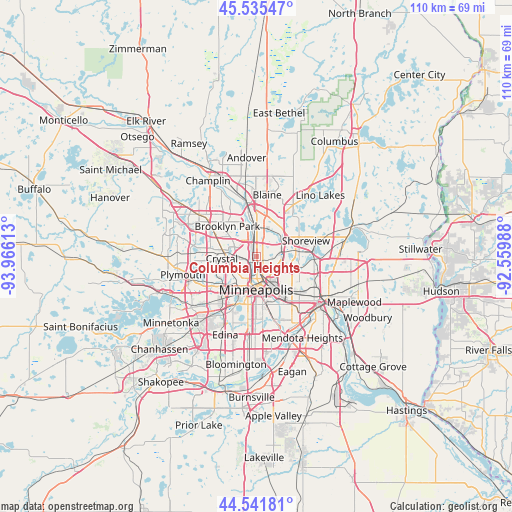
Columbia Heights GPS coordinates[2]
45° 2' 26.88" North, 93° 15' 46.8" West
| Map corner | latitude | longitude |
|---|---|---|
| Upper-left | 45.53547°, | -93.96613° |
| Center: | 45.0408°, | -93.263° |
| Lower-right: | 44.54181°, | -92.55988° |
| Map W x H: | 110.5×110.5 km | = 68.7×68.7mi |
| max Lat: | 71.29058° ⇑7.3% North |
| Columbia Heights: | 45.0408° |
| min Lat: | ⇓92.7% South 19.06759° |
| min Long | Columbia Height | max Long |
| -171.73463° | -93.263° | -66.98998° |
| W 33.1%⇐ | ⇒66.9% E |
Elevation
Elevation of Columbia Heights is 280 m = 919 ft, and this is 14.8 m = 49 ft below average elevation for this country.
| Max E: |
3189 m = 10463 ft | 31.1% |
| Avg. | 294.8 m = 967 ft | |
| Columbia Heights | 280 m = 919 ft | |
Min E: |
-60 m = -197 ft | 68.9% |
See also: United States elevation on elevation.city.
Geographical zone
Columbia Heights is located in North temperate zone (between Tropic of Cancer and the Arctic Circle). Distance of this North polar circle is 2393.1 km =1487 mi to North.| Distance of | km | miles | from Columbia Heights |
|---|---|---|---|
| North Pole | 4999 | 3106.2 | to North |
| Arctic Circle | 2393.1 | 1487 | to North |
| Tropic Cancer | 2402.1 | 1492.6 | to South |
| Equator | 5008.1 | 3111.9 | to South |


Nearby cities:
15 places around Columbia Heights: (largest is in red/bold)
• Arden Hills
8.4 km =5.2 mi,  82°
82°
• Brooklyn Center
6.7 km =4.2 mi,  305°
305°
• Coon Rapids
9 km =5.6 mi,  347°
347°
• Crystal
7.7 km =4.8 mi,  263°
263°
• Fridley
5 km =3.1 mi,  359°
359°
• Golden Valley
7.6 km =4.7 mi,  242°
242°
• Hilltop
1.9 km =1.2 mi,  41°
41°
• Lauderdale
6.5 km =4 mi,  136°
136°
• Minneapolis
6.8 km =4.2 mi,  180°
180°
• Mounds View
8.3 km =5.2 mi,  30°
30°
• New Brighton
5.5 km =3.4 mi,  60°
60°
• Robbinsdale
6 km =3.7 mi, 260°
• Roseville
9.2 km =5.7 mi,  114°
114°
• Saint Anthony
4.2 km =2.6 mi,  122°
122°
• Spring Lake Park
7.7 km =4.8 mi,  14°
14°
Sources, notices
• [Note1] Compared only with cities in United States existing in our database
• [Src1] Map data: © OpenStreetMap contributors (CC-BY-SA)
• [Src2] Other city data from geonames.org with taken over terms of usage.
• [Src3] Geographical zone / Annual Mean Temperature by Robert A. Rohde @ Wikipedia
