Dayton geodata
Dayton (Minnesota) is a populated place; located in United States in America/Chicago (GMT-5) time zone. With population of 5,096 people, there are 7081 cities with bigger population in this country. Compared to other cities in United States, 93.3% of cities are located further ↓South; 67.5% of cities are located further →East and 65.4% of cities have lower elevation than Dayton. Note1


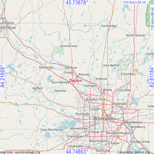
Dayton GPS coordinates[2]
45° 14' 37.86" North, 93° 30' 53.856" West
| Map corner | latitude | longitude |
|---|---|---|
| Upper-left | 45.73676°, | -94.21809° |
| Center: | 45.24385°, | -93.51496° |
| Lower-right: | 44.74663°, | -92.81184° |
| Map W x H: | 110.1×110.1 km | = 68.4×68.4mi |
| max Lat: | 71.29058° ⇑6.7% North |
| Dayton: | 45.24385° |
| min Lat: | ⇓93.3% South 19.06759° |
| min Long | Dayton | max Long |
| -171.73463° | -93.51496° | -66.98998° |
| W 32.5%⇐ | ⇒67.5% E |
Elevation
Elevation of Dayton is 264 m = 866 ft, and this is 30.8 m = 101 ft below average elevation for this country.
| Max E: |
3189 m = 10463 ft | 34.6% |
| Avg. | 294.8 m = 967 ft | |
| Dayton | 264 m = 866 ft | |
Min E: |
-60 m = -197 ft | 65.4% |
See also: United States elevation on elevation.city.
Geographical zone
Dayton is located in North temperate zone (between Tropic of Cancer and the Arctic Circle). Distance of this North polar circle is 2370.5 km =1473 mi to North.| Distance of | km | miles | from Dayton |
|---|---|---|---|
| North Pole | 4976.4 | 3092.2 | to North |
| Arctic Circle | 2370.5 | 1473 | to North |
| Tropic Cancer | 2424.7 | 1506.6 | to South |
| Equator | 5030.6 | 3125.9 | to South |


Nearby cities:
15 places around Dayton: (largest is in red/bold)
• Albertville
10.9 km =6.8 mi,  266°
266°
• Andover
17.5 km =10.9 mi,  93°
93°
• Anoka
11.2 km =7 mi,  117°
117°
• Champlin
11.1 km =6.9 mi, 123°
• Corcoran
16.7 km =10.4 mi,  188°
188°
• Elk River
7.8 km =4.8 mi,  328°
328°
• Hanover
15.4 km =9.6 mi,  230°
230°
• Nowthen
10 km =6.2 mi,  20°
20°
• Oak Grove
18.2 km =11.3 mi,  53°
53°
• Osseo
16.4 km =10.2 mi,  147°
147°
• Otsego
6.9 km =4.3 mi,  299°
299°
• Ramsey
5.4 km =3.4 mi,  69°
69°
• Rogers
6.8 km =4.2 mi,  205°
205°
• Saint Michael
12.3 km =7.6 mi,  252°
252°
• West Coon Rapids
16 km =9.9 mi,  125°
125°
Sources, notices
• [Note1] Compared only with cities in United States existing in our database
• [Src1] Map data: © OpenStreetMap contributors (CC-BY-SA)
• [Src2] Other city data from geonames.org with taken over terms of usage.
• [Src3] Geographical zone / Annual Mean Temperature by Robert A. Rohde @ Wikipedia
