Foley geodata
Foley (Minnesota) is a seat of a second-order administrative division; located in United States in America/Chicago (GMT-5) time zone. With population of 2,656 people, there are 10275 cities with bigger population in this country. Compared to other cities in United States, 94.5% of cities are located further ↓South; 68.4% of cities are located further →East and 79.1% of cities have lower elevation than Foley. Note1


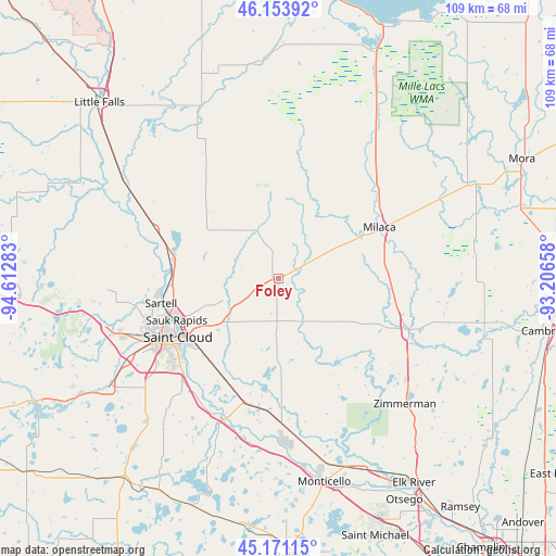
Foley GPS coordinates[2]
45° 39' 52.884" North, 93° 54' 34.92" West
| Map corner | latitude | longitude |
|---|---|---|
| Upper-left | 46.15392°, | -94.61283° |
| Center: | 45.66469°, | -93.9097° |
| Lower-right: | 45.17115°, | -93.20658° |
| Map W x H: | 109.3×109.3 km | = 67.9×67.9mi |
| max Lat: | 71.29058° ⇑5.5% North |
| Foley: | 45.66469° |
| min Lat: | ⇓94.5% South 19.06759° |
| min Long | Foley | max Long |
| -171.73463° | -93.9097° | -66.98998° |
| W 31.6%⇐ | ⇒68.4% E |
Elevation
Elevation of Foley is 345 m = 1132 ft, and this is 50.2 m = 165 ft above average elevation for this country.
| Max E: |
3189 m = 10463 ft | 20.9% |
| Foley | 345 m 1132 ft | |
| Avg. | 294.8 m = 967 ft | |
Min E: |
-60 m = -197 ft | 79.1% |
See also: United States elevation on elevation.city.
Geographical zone
Foley is located in North temperate zone (between Tropic of Cancer and the Arctic Circle). Distance of this North polar circle is 2323.7 km =1443.9 mi to North.| Distance of | km | miles | from Foley |
|---|---|---|---|
| North Pole | 4929.6 | 3063.1 | to North |
| Arctic Circle | 2323.7 | 1443.9 | to North |
| Tropic Cancer | 2471.5 | 1535.7 | to South |
| Equator | 5077.4 | 3154.9 | to South |


Nearby cities:
15 places around Foley: (largest is in red/bold)
• Becker
30.3 km =18.8 mi,  175°
175°
• Clear Lake
25.4 km =15.8 mi,  195°
195°
• Clearwater
29.3 km =18.2 mi, 201°
• Foreston
17.3 km =10.7 mi,  63°
63°
• Milaca
22.3 km =13.9 mi, 62°
• Princeton
27.6 km =17.1 mi,  112°
112°
• Rice
26 km =16.2 mi,  291°
291°
• Saint Augusta
28.1 km =17.5 mi,  222°
222°
• Saint Augusta
32.1 km =19.9 mi, 224°
• Saint Cloud
22.8 km =14.2 mi,  239°
239°
• Saint Joseph
33.7 km =20.9 mi,  250°
250°
• Saint Stephen
28.6 km =17.8 mi,  278°
278°
• Sartell
23.6 km =14.7 mi,  258°
258°
• Sauk Rapids
21.5 km =13.4 mi, 247°
• Waite Park
27.2 km =16.9 mi, 243°
Sources, notices
• [Note1] Compared only with cities in United States existing in our database
• [Src1] Map data: © OpenStreetMap contributors (CC-BY-SA)
• [Src2] Other city data from geonames.org with taken over terms of usage.
• [Src3] Geographical zone / Annual Mean Temperature by Robert A. Rohde @ Wikipedia
