Jackson geodata
Jackson (Minnesota) is a seat of a second-order administrative division; located in United States in America/Chicago (GMT-5) time zone. With population of 3,234 people, there are 9255 cities with bigger population in this country. Compared to other cities in United States, 86.8% of cities are located further ↓South; 71.1% of cities are located further →East and 83.4% of cities have lower elevation than Jackson. Note1


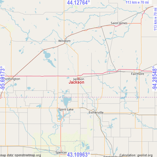
Jackson GPS coordinates[2]
43° 37' 14.844" North, 94° 59' 18.96" West
| Map corner | latitude | longitude |
|---|---|---|
| Upper-left | 44.12764°, | -95.69173° |
| Center: | 43.62079°, | -94.9886° |
| Lower-right: | 43.10963°, | -94.28548° |
| Map W x H: | 113.2×113.2 km | = 70.3×70.3mi |
| max Lat: | 71.29058° ⇑13.2% North |
| Jackson: | 43.62079° |
| min Lat: | ⇓86.8% South 19.06759° |
| min Long | Jackson | max Long |
| -171.73463° | -94.9886° | -66.98998° |
| W 28.9%⇐ | ⇒71.1% E |
Elevation
Elevation of Jackson is 396 m = 1299 ft, and this is 101.2 m = 332 ft above average elevation for this country.
| Max E: |
3189 m = 10463 ft | 16.6% |
| Jackson | 396 m 1299 ft | |
| Avg. | 294.8 m = 967 ft | |
Min E: |
-60 m = -197 ft | 83.4% |
See also: United States elevation on elevation.city.
Geographical zone
Jackson is located in North temperate zone (between Tropic of Cancer and the Arctic Circle). Distance of this Northern Tropic circle is 2244.3 km =1394.5 mi to South.| Distance of | km | miles | from Jackson |
|---|---|---|---|
| North Pole | 5156.9 | 3204.3 | to North |
| Arctic Circle | 2551 | 1585.1 | to North |
| Tropic Cancer | 2244.3 | 1394.5 | to South |
| Equator | 4850.2 | 3013.8 | to South |


Nearby cities:
15 places around Jackson: (largest is in red/bold)
• Arnolds Park
29.7 km =18.5 mi,  201°
201°
• Butterfield
40.6 km =25.2 mi,  22°
22°
• Estherville
27.4 km =17 mi,  152°
152°
• Heron Lake
33 km =20.5 mi,  305°
305°
• Lake Park
32.5 km =20.2 mi,  235°
235°
• Lakefield
16 km =9.9 mi,  293°
293°
• Milford
35.4 km =22 mi, 201°
• Mountain Lake
35.7 km =22.2 mi,  7°
7°
• Okoboji
29.1 km =18.1 mi,  206°
206°
• Orleans
21 km =13 mi, 203°
• Sherburn
21.3 km =13.2 mi,  80°
80°
• Spirit Lake
23.9 km =14.9 mi, 202°
• Trimont
27.5 km =17.1 mi,  55°
55°
• Welcome
30.1 km =18.7 mi, 80°
• Windom
29.2 km =18.1 mi,  339°
339°
Sources, notices
• [Note1] Compared only with cities in United States existing in our database
• [Src1] Map data: © OpenStreetMap contributors (CC-BY-SA)
• [Src2] Other city data from geonames.org with taken over terms of usage.
• [Src3] Geographical zone / Annual Mean Temperature by Robert A. Rohde @ Wikipedia
