East Kingston geodata
East Kingston (New Hampshire) is a populated place; located in United States in America/New_York (GMT-4) time zone. With population of 1,900 people, there are 12231 cities with bigger population in this country. Compared to other cities in United States, 82.7% of cities are located further ↓South; 97.6% of cities are located further ←West and 79.7% of cities have higher elevation than East Kingston. Note1
Administrative division(s):
- Level 1: New Hampshire
- Level 2: Rockingham County
- Level 3: Town of East Kingston


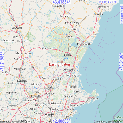
East Kingston GPS coordinates[2]
42° 55' 32.304" North, 71° 1' 0.192" West
| Map corner | latitude | longitude |
|---|---|---|
| Upper-left | 43.43834°, | -71.71985° |
| Center: | 42.92564°, | -71.01672° |
| Lower-right: | 42.40863°, | -70.3136° |
| Map W x H: | 114.5×114.5 km | = 71.1×71.1mi |
| max Lat: | 71.29058° ⇑17.3% North |
| East Kingston: | 42.92564° |
| min Lat: | ⇓82.7% South 19.06759° |
| min Long | East Kingston | max Long |
| -171.73463° | -71.01672° | -66.98998° |
| W 97.6%⇐ | ⇒2.4% E |
Elevation
Elevation of East Kingston is 48 m = 157 ft, and this is 246.8 m = 810 ft below average elevation for this country.
| Max E: |
3189 m = 10463 ft | 79.7% |
| Avg. | 294.8 m = 967 ft | |
| East Kingston | 48 m = 157 ft | |
Min E: |
-60 m = -197 ft | 20.3% |
See also: United States elevation on elevation.city.
Geographical zone
East Kingston is located in North temperate zone (between Tropic of Cancer and the Arctic Circle). Distance of this Northern Tropic circle is 2167 km =1346.5 mi to South.| Distance of | km | miles | from East Kingston |
|---|---|---|---|
| North Pole | 5234.2 | 3252.4 | to North |
| Arctic Circle | 2628.3 | 1633.1 | to North |
| Tropic Cancer | 2167 | 1346.5 | to South |
| Equator | 4772.9 | 2965.7 | to South |


Nearby cities:
15 places around East Kingston: (largest is in red/bold)
• Amesbury
10.3 km =6.4 mi,  136°
136°
• Brentwood
7.5 km =4.7 mi,  322°
322°
• Danville
8.9 km =5.5 mi,  260°
260°
• Epping
12.9 km =8 mi,  338°
338°
• Exeter
8.4 km =5.2 mi,  42°
42°
• Fremont
12.6 km =7.8 mi,  305°
305°
• Hampton Falls
12.5 km =7.8 mi,  94°
94°
• Kensington
5.9 km =3.7 mi, 88°
• Kingston
3.2 km =2 mi,  291°
291°
• Merrimac
10.6 km =6.6 mi,  173°
173°
• Newton
6.4 km =4 mi,  193°
193°
• Plaistow
11.8 km =7.3 mi,  212°
212°
• Sandown
13.9 km =8.6 mi,  271°
271°
• Seabrook
12.3 km =7.6 mi,  106°
106°
• South Hampton
6.6 km =4.1 mi, 138°
Sources, notices
• [Note1] Compared only with cities in United States existing in our database
• [Src1] Map data: © OpenStreetMap contributors (CC-BY-SA)
• [Src2] Other city data from geonames.org with taken over terms of usage.
• [Src3] Geographical zone / Annual Mean Temperature by Robert A. Rohde @ Wikipedia
