Greenville geodata
Greenville (New Hampshire) is a populated place; located in United States in America/New_York (GMT-4) time zone. With population of 1,108 people, there are 15629 cities with bigger population in this country. Compared to other cities in United States, 81.7% of cities are located further ↓South; 96% of cities are located further ←West and 63.5% of cities have lower elevation than Greenville. Note1
Administrative division(s):
- Level 1: New Hampshire
- Level 2: Hillsborough County
- Level 3: Town of Greenville


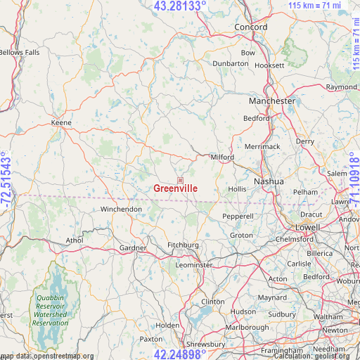
Greenville GPS coordinates[2]
42° 46' 2.316" North, 71° 48' 44.28" West
| Map corner | latitude | longitude |
|---|---|---|
| Upper-left | 43.28133°, | -72.51543° |
| Center: | 42.76731°, | -71.8123° |
| Lower-right: | 42.24898°, | -71.10918° |
| Map W x H: | 114.8×114.8 km | = 71.3×71.3mi |
| max Lat: | 71.29058° ⇑18.3% North |
| Greenville: | 42.76731° |
| min Lat: | ⇓81.7% South 19.06759° |
| min Long | Greenville | max Long |
| -171.73463° | -71.8123° | -66.98998° |
| W 96%⇐ | ⇒4% E |
Elevation
Elevation of Greenville is 255 m = 837 ft, and this is 39.8 m = 131 ft below average elevation for this country.
| Max E: |
3189 m = 10463 ft | 36.5% |
| Avg. | 294.8 m = 967 ft | |
| Greenville | 255 m = 837 ft | |
Min E: |
-60 m = -197 ft | 63.5% |
See also: United States elevation on elevation.city.
Geographical zone
Greenville is located in North temperate zone (between Tropic of Cancer and the Arctic Circle). Distance of this Northern Tropic circle is 2149.4 km =1335.6 mi to South.| Distance of | km | miles | from Greenville |
|---|---|---|---|
| North Pole | 5251.8 | 3263.3 | to North |
| Arctic Circle | 2645.9 | 1644.1 | to North |
| Tropic Cancer | 2149.4 | 1335.6 | to South |
| Equator | 4755.3 | 2954.8 | to South |


Nearby cities:
15 places around Greenville: (largest is in red/bold)
• Ashburnham
16.5 km =10.3 mi,  208°
208°
• Ashby
10 km =6.2 mi,  183°
183°
• Brookline
13.1 km =8.1 mi,  106°
106°
• Hollis
18.2 km =11.3 mi,  98°
98°
• Jaffrey
18 km =11.2 mi,  286°
286°
• Lyndeborough
16 km =9.9 mi,  13°
13°
• Mason
4.4 km =2.7 mi,  126°
126°
• Milford
15.3 km =9.5 mi,  60°
60°
• Mont Vernon
18.1 km =11.2 mi,  38°
38°
• New Ipswich
4 km =2.5 mi,  238°
238°
• Peterborough
16.2 km =10.1 mi,  315°
315°
• Rindge
16.2 km =10.1 mi,  263°
263°
• Temple
6.5 km =4 mi,  330°
330°
• Townsend
14.2 km =8.8 mi,  141°
141°
• Wilton
10.6 km =6.6 mi, 36°
Sources, notices
• [Note1] Compared only with cities in United States existing in our database
• [Src1] Map data: © OpenStreetMap contributors (CC-BY-SA)
• [Src2] Other city data from geonames.org with taken over terms of usage.
• [Src3] Geographical zone / Annual Mean Temperature by Robert A. Rohde @ Wikipedia
