Nottingham geodata
Nottingham (New Hampshire) is a populated place; located in United States in America/New_York (GMT-4) time zone. With population of 3,942 people, there are 8275 cities with bigger population in this country. Compared to other cities in United States, 84.2% of cities are located further ↓South; 97.4% of cities are located further ←West and 72.8% of cities have higher elevation than Nottingham. Note1
Administrative division(s):
- Level 1: New Hampshire
- Level 2: Rockingham County
- Level 3: Town of Nottingham


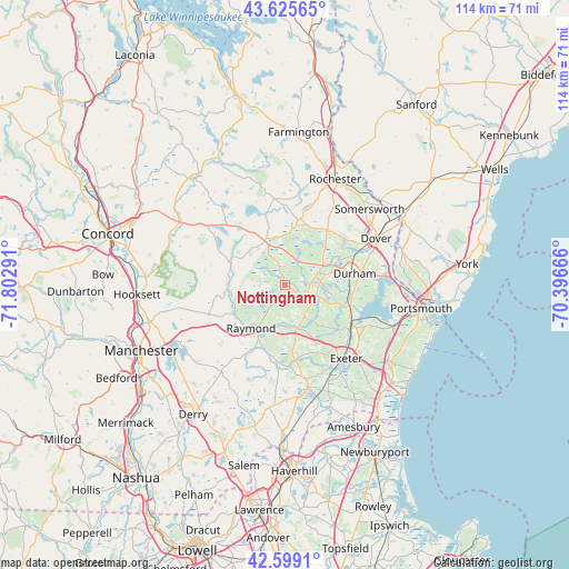
Nottingham GPS coordinates[2]
43° 6' 52.308" North, 71° 5' 59.208" West
| Map corner | latitude | longitude |
|---|---|---|
| Upper-left | 43.62565°, | -71.80291° |
| Center: | 43.11453°, | -71.09978° |
| Lower-right: | 42.5991°, | -70.39666° |
| Map W x H: | 114.1×114.1 km | = 70.9×70.9mi |
| max Lat: | 71.29058° ⇑15.8% North |
| Nottingham: | 43.11453° |
| min Lat: | ⇓84.2% South 19.06759° |
| min Long | Nottingham | max Long |
| -171.73463° | -71.09978° | -66.98998° |
| W 97.4%⇐ | ⇒2.6% E |
Elevation
Elevation of Nottingham is 84 m = 276 ft, and this is 210.8 m = 692 ft below average elevation for this country.
| Max E: |
3189 m = 10463 ft | 72.8% |
| Avg. | 294.8 m = 967 ft | |
| Nottingham | 84 m = 276 ft | |
Min E: |
-60 m = -197 ft | 27.2% |
See also: United States elevation on elevation.city.
Geographical zone
Nottingham is located in North temperate zone (between Tropic of Cancer and the Arctic Circle). Distance of this Northern Tropic circle is 2188 km =1359.6 mi to South.| Distance of | km | miles | from Nottingham |
|---|---|---|---|
| North Pole | 5213.2 | 3239.3 | to North |
| Arctic Circle | 2607.3 | 1620.1 | to North |
| Tropic Cancer | 2188 | 1359.6 | to South |
| Equator | 4793.9 | 2978.8 | to South |


Nearby cities:
15 places around Nottingham: (largest is in red/bold)
• Barrington
12.8 km =8 mi,  19°
19°
• Brentwood
15.3 km =9.5 mi,  171°
171°
• Candia
14.9 km =9.3 mi,  254°
254°
• Dover
20.5 km =12.7 mi,  63°
63°
• Durham
14.2 km =8.8 mi,  81°
81°
• Epping
9.3 km =5.8 mi, 167°
• Exeter
19.3 km =12 mi,  140°
140°
• Fremont
14.2 km =8.8 mi,  194°
194°
• Kingston
20.2 km =12.6 mi, 169°
• Lee
7.2 km =4.5 mi, 82°
• Madbury
15.5 km =9.6 mi,  66°
66°
• Newmarket
13.8 km =8.6 mi,  104°
104°
• Northwood
9.8 km =6.1 mi,  334°
334°
• Raymond
11 km =6.8 mi,  217°
217°
• Stratham Station
18 km =11.2 mi,  112°
112°
Sources, notices
• [Note1] Compared only with cities in United States existing in our database
• [Src1] Map data: © OpenStreetMap contributors (CC-BY-SA)
• [Src2] Other city data from geonames.org with taken over terms of usage.
• [Src3] Geographical zone / Annual Mean Temperature by Robert A. Rohde @ Wikipedia
