Sutton geodata
Sutton (New Hampshire) is a populated place; located in United States in America/New_York (GMT-4) time zone. With population of 1,644 people, there are 13109 cities with bigger population in this country. Compared to other cities in United States, 85.6% of cities are located further ↓South; 95.8% of cities are located further ←West and 57.2% of cities have lower elevation than Sutton. Note1
Administrative division(s):
- Level 1: New Hampshire
- Level 2: Merrimack County
- Level 3: Town of Sutton


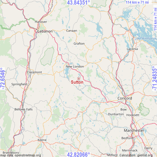
Sutton GPS coordinates[2]
43° 20' 3.264" North, 71° 57' 5.292" West
| Map corner | latitude | longitude |
|---|---|---|
| Upper-left | 43.84351°, | -72.6546° |
| Center: | 43.33424°, | -71.95147° |
| Lower-right: | 42.82066°, | -71.24835° |
| Map W x H: | 113.7×113.7 km | = 70.6×70.6mi |
| max Lat: | 71.29058° ⇑14.4% North |
| Sutton: | 43.33424° |
| min Lat: | ⇓85.6% South 19.06759° |
| min Long | Sutton | max Long |
| -171.73463° | -71.95147° | -66.98998° |
| W 95.8%⇐ | ⇒4.2% E |
Elevation
Elevation of Sutton is 227 m = 745 ft, and this is 67.8 m = 222 ft below average elevation for this country.
| Max E: |
3189 m = 10463 ft | 42.8% |
| Avg. | 294.8 m = 967 ft | |
| Sutton | 227 m = 745 ft | |
Min E: |
-60 m = -197 ft | 57.2% |
See also: United States elevation on elevation.city.
Geographical zone
Sutton is located in North temperate zone (between Tropic of Cancer and the Arctic Circle). Distance of this Northern Tropic circle is 2212.4 km =1374.7 mi to South.| Distance of | km | miles | from Sutton |
|---|---|---|---|
| North Pole | 5188.7 | 3224.1 | to North |
| Arctic Circle | 2582.9 | 1604.9 | to North |
| Tropic Cancer | 2212.4 | 1374.7 | to South |
| Equator | 4818.3 | 2994 | to South |


Nearby cities:
15 places around Sutton: (largest is in red/bold)
• Andover
15.4 km =9.6 mi,  42°
42°
• Contoocook
22.9 km =14.2 mi,  122°
122°
• Croydon
21.4 km =13.3 mi,  307°
307°
• Danbury
22.5 km =14 mi,  18°
18°
• Goshen
16.3 km =10.1 mi,  256°
256°
• Henniker
20.1 km =12.5 mi,  148°
148°
• New London
9.3 km =5.8 mi,  342°
342°
• Newbury
7 km =4.3 mi, 258°
• Newport
18.3 km =11.4 mi,  280°
280°
• Salisbury
19.6 km =12.2 mi,  74°
74°
• Springfield
19.1 km =11.9 mi, 339°
• Sunapee
12.5 km =7.8 mi,  298°
298°
• Washington
21.2 km =13.2 mi,  213°
213°
• Webster
18.9 km =11.7 mi,  91°
91°
• Wilmot
13.4 km =8.3 mi,  13°
13°
Sources, notices
• [Note1] Compared only with cities in United States existing in our database
• [Src1] Map data: © OpenStreetMap contributors (CC-BY-SA)
• [Src2] Other city data from geonames.org with taken over terms of usage.
• [Src3] Geographical zone / Annual Mean Temperature by Robert A. Rohde @ Wikipedia
