Bayonne geodata
Bayonne (New Jersey) is a populated place; located in United States in America/New_York (GMT-4) time zone. With population of 66,311 people, there are 642 cities with bigger population in this country. Compared to other cities in United States, 61.1% of cities are located further ↓South; 89.9% of cities are located further ←West and 91% of cities have higher elevation than Bayonne. Note1


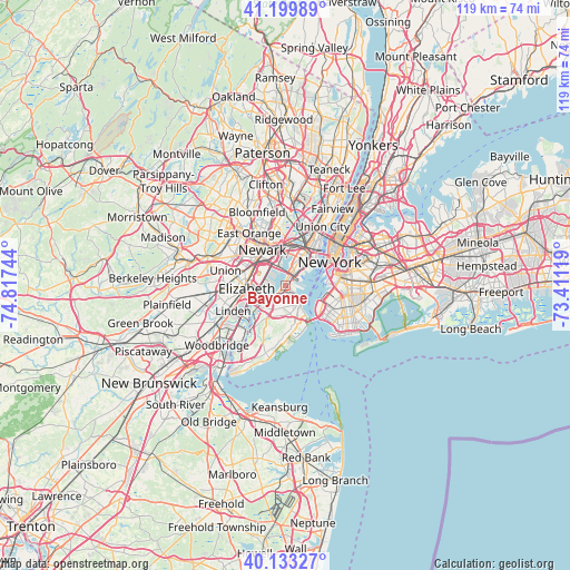
Bayonne GPS coordinates[2]
40° 40' 7.356" North, 74° 6' 51.516" West
| Map corner | latitude | longitude |
|---|---|---|
| Upper-left | 41.19989°, | -74.81744° |
| Center: | 40.66871°, | -74.11431° |
| Lower-right: | 40.13327°, | -73.41119° |
| Map W x H: | 118.6×118.6 km | = 73.7×73.7mi |
| max Lat: | 71.29058° ⇑38.9% North |
| Bayonne: | 40.66871° |
| min Lat: | ⇓61.1% South 19.06759° |
| min Long | Bayonne | max Long |
| -171.73463° | -74.11431° | -66.98998° |
| W 89.9%⇐ | ⇒10.1% E |
Elevation
Elevation of Bayonne is 14 m = 46 ft, and this is 280.8 m = 921 ft below average elevation for this country.
| Max E: |
3189 m = 10463 ft | 91% |
| Avg. | 294.8 m = 967 ft | |
| Bayonne | 14 m = 46 ft | |
Min E: |
-60 m = -197 ft | 9% |
See also: Bayonne elevation on elevation.city.
Geographical zone
Bayonne is located in North temperate zone (between Tropic of Cancer and the Arctic Circle). Distance of this Northern Tropic circle is 1916 km =1190.5 mi to South.| Distance of | km | miles | from Bayonne |
|---|---|---|---|
| North Pole | 5485.1 | 3408.3 | to North |
| Arctic Circle | 2879.2 | 1789.1 | to North |
| Tropic Cancer | 1916 | 1190.5 | to South |
| Equator | 4521.9 | 2809.8 | to South |


Nearby cities:
15 places around Bayonne: (largest is in red/bold)
• Clifton
6.3 km =3.9 mi,  149°
149°
• Concord
7.2 km =4.5 mi,  159°
159°
• Elizabeth
8.1 km =5 mi,  266°
266°
• Emerson Hill
6.8 km =4.2 mi,  166°
166°
• Graniteville
5.7 km =3.5 mi,  210°
210°
• Grymes Hill
5.8 km =3.6 mi, 162°
• Jersey City
7.3 km =4.5 mi,  25°
25°
• Mariners Harbor
5.2 km =3.2 mi,  226°
226°
• New Brighton
3.4 km =2.1 mi, 148°
• Port Richmond
4.4 km =2.7 mi, 205°
• Rosebank
7.3 km =4.5 mi, 146°
• Stapleton
5.6 km =3.5 mi, 146°
• Tompkinsville
4.6 km =2.9 mi,  137°
137°
• Westerleigh
5.5 km =3.4 mi,  195°
195°
• Willowbrook
7.6 km =4.7 mi, 195°
Sources, notices
• [Note1] Compared only with cities in United States existing in our database
• [Src1] Map data: © OpenStreetMap contributors (CC-BY-SA)
• [Src2] Other city data from geonames.org with taken over terms of usage.
• [Src3] Geographical zone / Annual Mean Temperature by Robert A. Rohde @ Wikipedia
