Ho-Ho-Kus geodata
Ho-Ho-Kus (New Jersey) is a populated place; located in United States in America/New_York (GMT-4) time zone. With population of 4,165 people, there are 8031 cities with bigger population in this country. Compared to other cities in United States, 65.8% of cities are located further ↓South; 90% of cities are located further ←West and 80.6% of cities have higher elevation than Ho-Ho-Kus. Note1
Administrative division(s):
- Level 1: New Jersey
- Level 2: Bergen County
- Level 3: Borough of Ho-Ho-Kus


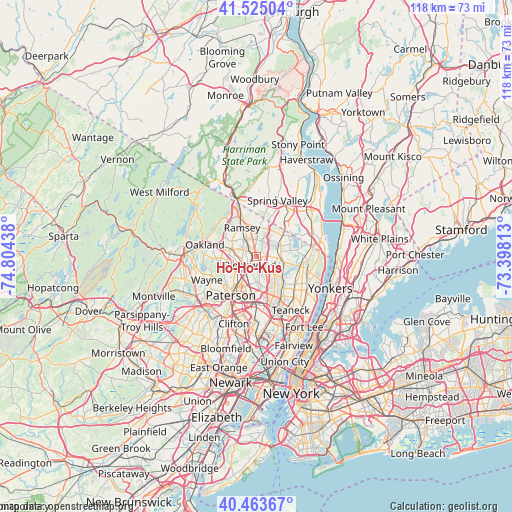
Ho-Ho-Kus GPS coordinates[2]
40° 59' 47.364" North, 74° 6' 4.5" West
| Map corner | latitude | longitude |
|---|---|---|
| Upper-left | 41.52504°, | -74.80438° |
| Center: | 40.99649°, | -74.10125° |
| Lower-right: | 40.46367°, | -73.39813° |
| Map W x H: | 118×118 km | = 73.3×73.3mi |
| max Lat: | 71.29058° ⇑34.2% North |
| Ho-Ho-Kus: | 40.99649° |
| min Lat: | ⇓65.8% South 19.06759° |
| min Long | Ho-Ho-Kus | max Long |
| -171.73463° | -74.10125° | -66.98998° |
| W 90%⇐ | ⇒10% E |
Elevation
Elevation of Ho-Ho-Kus is 44 m = 144 ft, and this is 250.8 m = 823 ft below average elevation for this country.
| Max E: |
3189 m = 10463 ft | 80.6% |
| Avg. | 294.8 m = 967 ft | |
| Ho-Ho-Kus | 44 m = 144 ft | |
Min E: |
-60 m = -197 ft | 19.4% |
See also: United States elevation on elevation.city.
Geographical zone
Ho-Ho-Kus is located in North temperate zone (between Tropic of Cancer and the Arctic Circle). Distance of this Northern Tropic circle is 1952.5 km =1213.2 mi to South.| Distance of | km | miles | from Ho-Ho-Kus |
|---|---|---|---|
| North Pole | 5448.7 | 3385.7 | to North |
| Arctic Circle | 2842.8 | 1766.4 | to North |
| Tropic Cancer | 1952.5 | 1213.2 | to South |
| Equator | 4558.4 | 2832.5 | to South |


Nearby cities:
15 places around Ho-Ho-Kus: (largest is in red/bold)
• Allendale
5.5 km =3.4 mi,  335°
335°
• Emerson
6.7 km =4.2 mi,  109°
109°
• Fair Lawn
6.7 km =4.2 mi,  202°
202°
• Glen Rock
4.6 km =2.9 mi,  215°
215°
• Hillsdale
5.1 km =3.2 mi,  82°
82°
• Midland Park
3.4 km =2.1 mi,  256°
256°
• Oradell
6.8 km =4.2 mi,  127°
127°
• Paramus
6.2 km =3.9 mi,  159°
159°
• Park Ridge
6.8 km =4.2 mi,  48°
48°
• Ridgewood
2.3 km =1.4 mi,  213°
213°
• Saddle River
3.9 km =2.4 mi,  358°
358°
• Waldwick
2.1 km =1.3 mi,  318°
318°
• Westwood
5.8 km =3.6 mi,  95°
95°
• Woodcliff Lake
4.2 km =2.6 mi,  44°
44°
• Wyckoff
6.2 km =3.9 mi,  283°
283°
Sources, notices
• [Note1] Compared only with cities in United States existing in our database
• [Src1] Map data: © OpenStreetMap contributors (CC-BY-SA)
• [Src2] Other city data from geonames.org with taken over terms of usage.
• [Src3] Geographical zone / Annual Mean Temperature by Robert A. Rohde @ Wikipedia
