Netcong geodata
Netcong (New Jersey) is a populated place; located in United States in America/New_York (GMT-4) time zone. With population of 3,253 people, there are 9225 cities with bigger population in this country. Compared to other cities in United States, 64.7% of cities are located further ↓South; 88% of cities are located further ←West and 66.1% of cities have lower elevation than Netcong. Note1


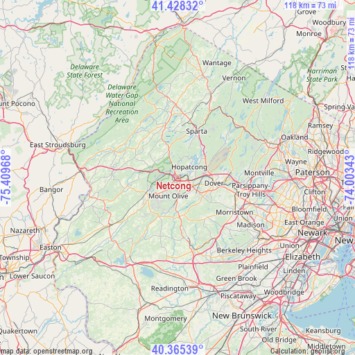
Netcong GPS coordinates[2]
40° 53' 56.364" North, 74° 42' 23.58" West
| Map corner | latitude | longitude |
|---|---|---|
| Upper-left | 41.42832°, | -75.40968° |
| Center: | 40.89899°, | -74.70655° |
| Lower-right: | 40.36539°, | -74.00343° |
| Map W x H: | 118.2×118.2 km | = 73.4×73.4mi |
| max Lat: | 71.29058° ⇑35.3% North |
| Netcong: | 40.89899° |
| min Lat: | ⇓64.7% South 19.06759° |
| min Long | Netcong | max Long |
| -171.73463° | -74.70655° | -66.98998° |
| W 88%⇐ | ⇒12% E |
Elevation
Elevation of Netcong is 267 m = 876 ft, and this is 27.8 m = 91 ft below average elevation for this country.
| Max E: |
3189 m = 10463 ft | 33.9% |
| Avg. | 294.8 m = 967 ft | |
| Netcong | 267 m = 876 ft | |
Min E: |
-60 m = -197 ft | 66.1% |
See also: United States elevation on elevation.city.
Geographical zone
Netcong is located in North temperate zone (between Tropic of Cancer and the Arctic Circle). Distance of this Northern Tropic circle is 1941.6 km =1206.5 mi to South.| Distance of | km | miles | from Netcong |
|---|---|---|---|
| North Pole | 5459.5 | 3392.4 | to North |
| Arctic Circle | 2853.6 | 1773.1 | to North |
| Tropic Cancer | 1941.6 | 1206.5 | to South |
| Equator | 4547.5 | 2825.7 | to South |


Nearby cities:
15 places around Netcong: (largest is in red/bold)
• Andover
10.1 km =6.3 mi,  342°
342°
• Budd Lake
3.9 km =2.4 mi,  216°
216°
• Chester
12.8 km =8 mi,  176°
176°
• Dover
12.3 km =7.6 mi,  97°
97°
• Hackettstown
11.5 km =7.1 mi,  244°
244°
• Hopatcong
5.5 km =3.4 mi,  46°
46°
• Hopatcong Hills
5.8 km =3.6 mi,  31°
31°
• Kenvil
7.7 km =4.8 mi,  106°
106°
• Lake Mohawk
13.8 km =8.6 mi,  16°
16°
• Landing
3.5 km =2.2 mi,  78°
78°
• Mount Arlington
6.7 km =4.2 mi,  63°
63°
• Randolph
11.9 km =7.4 mi,  118°
118°
• Stanhope
0.5 km =0.3 mi,  334°
334°
• Succasunna
6.5 km =4 mi, 121°
• Wharton
10.5 km =6.5 mi,  93°
93°
Sources, notices
• [Note1] Compared only with cities in United States existing in our database
• [Src1] Map data: © OpenStreetMap contributors (CC-BY-SA)
• [Src2] Other city data from geonames.org with taken over terms of usage.
• [Src3] Geographical zone / Annual Mean Temperature by Robert A. Rohde @ Wikipedia
