Sayreville geodata
Sayreville (New Jersey) is a populated place; located in United States in America/New_York (GMT-4) time zone. With population of 44,920 people, there are 1061 cities with bigger population in this country. Compared to other cities in United States, 58.5% of cities are located further ↓South; 88.9% of cities are located further ←West and 86.6% of cities have higher elevation than Sayreville. Note1
Administrative division(s):
- Level 1: New Jersey
- Level 2: Middlesex County
- Level 3: Borough of Sayreville


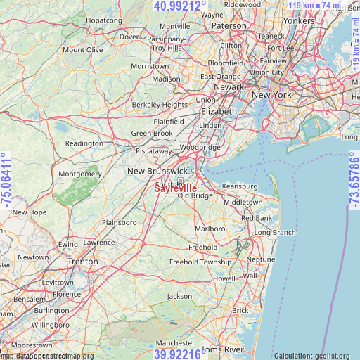
Sayreville GPS coordinates[2]
40° 27' 33.372" North, 74° 21' 39.528" West
| Map corner | latitude | longitude |
|---|---|---|
| Upper-left | 40.99212°, | -75.06411° |
| Center: | 40.45927°, | -74.36098° |
| Lower-right: | 39.92216°, | -73.65786° |
| Map W x H: | 119×119 km | = 73.9×73.9mi |
| max Lat: | 71.29058° ⇑41.5% North |
| Sayreville: | 40.45927° |
| min Lat: | ⇓58.5% South 19.06759° |
| min Long | Sayreville | max Long |
| -171.73463° | -74.36098° | -66.98998° |
| W 88.9%⇐ | ⇒11.1% E |
Elevation
Elevation of Sayreville is 24 m = 79 ft, and this is 270.8 m = 888 ft below average elevation for this country.
| Max E: |
3189 m = 10463 ft | 86.6% |
| Avg. | 294.8 m = 967 ft | |
| Sayreville | 24 m = 79 ft | |
Min E: |
-60 m = -197 ft | 13.4% |
See also: Sayreville elevation on elevation.city.
Geographical zone
Sayreville is located in North temperate zone (between Tropic of Cancer and the Arctic Circle). Distance of this Northern Tropic circle is 1892.7 km =1176.1 mi to South.| Distance of | km | miles | from Sayreville |
|---|---|---|---|
| North Pole | 5508.4 | 3422.8 | to North |
| Arctic Circle | 2902.5 | 1803.5 | to North |
| Tropic Cancer | 1892.7 | 1176.1 | to South |
| Equator | 4498.6 | 2795.3 | to South |


Nearby cities:
15 places around Sayreville: (largest is in red/bold)
• Brownville
8.6 km =5.3 mi,  139°
139°
• East Brunswick
5.8 km =3.6 mi,  233°
233°
• Edison
7.9 km =4.9 mi,  326°
326°
• Fords
8.7 km =5.4 mi,  26°
26°
• Highland Park
6.7 km =4.2 mi,  307°
307°
• Madison Park
4.6 km =2.9 mi,  100°
100°
• Milltown
7 km =4.3 mi,  267°
267°
• New Brunswick
8.2 km =5.1 mi,  291°
291°
• Old Bridge
5 km =3.1 mi,  184°
184°
• Piscataway
5.5 km =3.4 mi,  324°
324°
• Sayreville Junction
2.7 km =1.7 mi,  75°
75°
• South Amboy
6.3 km =3.9 mi,  70°
70°
• South Old Bridge
5.7 km =3.5 mi,  174°
174°
• South River
2.5 km =1.6 mi,  236°
236°
• Spotswood
8.1 km =5 mi,  202°
202°
Sources, notices
• [Note1] Compared only with cities in United States existing in our database
• [Src1] Map data: © OpenStreetMap contributors (CC-BY-SA)
• [Src2] Other city data from geonames.org with taken over terms of usage.
• [Src3] Geographical zone / Annual Mean Temperature by Robert A. Rohde @ Wikipedia
