Auburn geodata
Auburn (New York) is a seat of a second-order administrative division; located in United States in America/New_York (GMT-4) time zone. With population of 26,985 people, there are 1856 cities with bigger population in this country. Compared to other cities in United States, 82.8% of cities are located further ↓South; 82.4% of cities are located further ←West and 53.7% of cities have lower elevation than Auburn. Note1


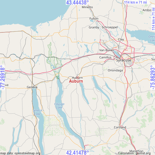
Auburn GPS coordinates[2]
42° 55' 54.228" North, 76° 33' 57.78" West
| Map corner | latitude | longitude |
|---|---|---|
| Upper-left | 43.44438°, | -77.26918° |
| Center: | 42.93173°, | -76.56605° |
| Lower-right: | 42.41478°, | -75.86293° |
| Map W x H: | 114.5×114.5 km | = 71.1×71.1mi |
| max Lat: | 71.29058° ⇑17.2% North |
| Auburn: | 42.93173° |
| min Lat: | ⇓82.8% South 19.06759° |
| min Long | Auburn | max Long |
| -171.73463° | -76.56605° | -66.98998° |
| W 82.4%⇐ | ⇒17.6% E |
Elevation
Elevation of Auburn is 213 m = 699 ft, and this is 81.8 m = 268 ft below average elevation for this country.
| Max E: |
3189 m = 10463 ft | 46.3% |
| Avg. | 294.8 m = 967 ft | |
| Auburn | 213 m = 699 ft | |
Min E: |
-60 m = -197 ft | 53.7% |
See also: United States elevation on elevation.city.
Geographical zone
Auburn is located in North temperate zone (between Tropic of Cancer and the Arctic Circle). Distance of this Northern Tropic circle is 2167.6 km =1346.9 mi to South.| Distance of | km | miles | from Auburn |
|---|---|---|---|
| North Pole | 5233.5 | 3251.9 | to North |
| Arctic Circle | 2627.6 | 1632.7 | to North |
| Tropic Cancer | 2167.6 | 1346.9 | to South |
| Equator | 4773.6 | 2966.2 | to South |


Nearby cities:
15 places around Auburn: (largest is in red/bold)
• Aurora
22.7 km =14.1 mi,  209°
209°
• Bridgeport
15.3 km =9.5 mi,  263°
263°
• Cayuga
13.1 km =8.1 mi, 263°
• Centerport
12.3 km =7.6 mi,  349°
349°
• Elbridge
14.9 km =9.3 mi,  40°
40°
• Jordan
16.7 km =10.4 mi,  26°
26°
• Marcellus
19.2 km =11.9 mi,  72°
72°
• Melrose Park
3.3 km =2.1 mi,  140°
140°
• Peru
21.1 km =13.1 mi, 37°
• Port Byron
12.4 km =7.7 mi,  337°
337°
• Savannah
21.8 km =13.5 mi,  313°
313°
• Seneca Falls
18.9 km =11.7 mi, 262°
• Skaneateles
11.3 km =7 mi,  81°
81°
• Union Springs
14.6 km =9.1 mi,  225°
225°
• Weedsport
13 km =8.1 mi,  1°
1°
Sources, notices
• [Note1] Compared only with cities in United States existing in our database
• [Src1] Map data: © OpenStreetMap contributors (CC-BY-SA)
• [Src2] Other city data from geonames.org with taken over terms of usage.
• [Src3] Geographical zone / Annual Mean Temperature by Robert A. Rohde @ Wikipedia
