Bayside geodata
Bayside (New York) is a populated place; located in United States in America/New_York (GMT-4) time zone. With population of 66,455 people, there are 641 cities with bigger population in this country. Compared to other cities in United States, 62.6% of cities are located further ↓South; 91.7% of cities are located further ←West and 85.4% of cities have higher elevation than Bayside. Note1


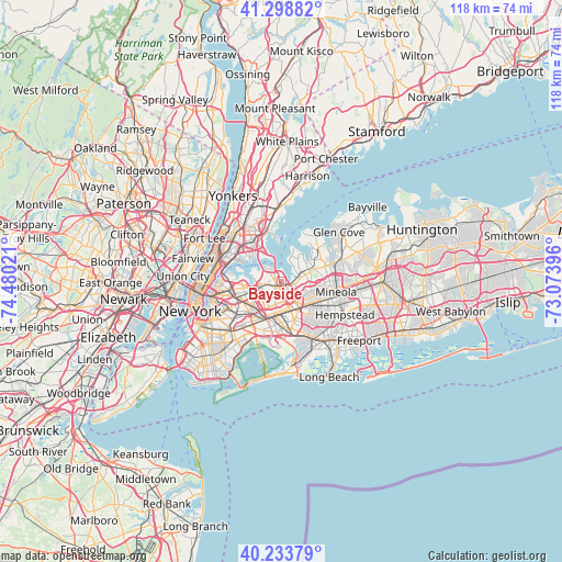
Bayside GPS coordinates[2]
40° 46' 6.384" North, 73° 46' 37.488" West
| Map corner | latitude | longitude |
|---|---|---|
| Upper-left | 41.29882°, | -74.48021° |
| Center: | 40.76844°, | -73.77708° |
| Lower-right: | 40.23379°, | -73.07396° |
| Map W x H: | 118.4×118.4 km | = 73.6×73.6mi |
| max Lat: | 71.29058° ⇑37.4% North |
| Bayside: | 40.76844° |
| min Lat: | ⇓62.6% South 19.06759° |
| min Long | Bayside | max Long |
| -171.73463° | -73.77708° | -66.98998° |
| W 91.7%⇐ | ⇒8.3% E |
Elevation
Elevation of Bayside is 27 m = 89 ft, and this is 267.8 m = 879 ft below average elevation for this country.
| Max E: |
3189 m = 10463 ft | 85.4% |
| Avg. | 294.8 m = 967 ft | |
| Bayside | 27 m = 89 ft | |
Min E: |
-60 m = -197 ft | 14.6% |
See also: Bayside elevation on elevation.city.
Geographical zone
Bayside is located in North temperate zone (between Tropic of Cancer and the Arctic Circle). Distance of this Northern Tropic circle is 1927.1 km =1197.4 mi to South.| Distance of | km | miles | from Bayside |
|---|---|---|---|
| North Pole | 5474 | 3401.4 | to North |
| Arctic Circle | 2868.1 | 1782.2 | to North |
| Tropic Cancer | 1927.1 | 1197.4 | to South |
| Equator | 4533 | 2816.7 | to South |


Nearby cities:
15 places around Bayside: (largest is in red/bold)
• Douglaston
2.5 km =1.6 mi,  89°
89°
• East Atlantic Beach
3.5 km =2.2 mi,  46°
46°
• Fresh Meadows
4 km =2.5 mi,  200°
200°
• Great Neck
5.4 km =3.4 mi, 48°
• Great Neck Estates
4 km =2.5 mi,  58°
58°
• Great Neck Plaza
4.7 km =2.9 mi, 64°
• Harbor Hills
3.6 km =2.2 mi, 45°
• Kensington
5.4 km =3.4 mi, 59°
• Lake Success
5 km =3.1 mi, 87°
• Little Neck
3.8 km =2.4 mi,  99°
99°
• Russell Gardens
4.6 km =2.9 mi,  72°
72°
• Saddle Rock
3.7 km =2.3 mi,  39°
39°
• Terrace Heights
5.3 km =3.3 mi,  172°
172°
• University Gardens
4.7 km =2.9 mi,  77°
77°
• Whitestone
4.5 km =2.8 mi,  309°
309°
Sources, notices
• [Note1] Compared only with cities in United States existing in our database
• [Src1] Map data: © OpenStreetMap contributors (CC-BY-SA)
• [Src2] Other city data from geonames.org with taken over terms of usage.
• [Src3] Geographical zone / Annual Mean Temperature by Robert A. Rohde @ Wikipedia
