Brentwood geodata
Brentwood (New York) is a populated place; located in United States in America/New_York (GMT-4) time zone. With population of 60,664 people, there are 728 cities with bigger population in this country. Compared to other cities in United States, 62.8% of cities are located further ↓South; 93.3% of cities are located further ←West and 85.8% of cities have higher elevation than Brentwood. Note1


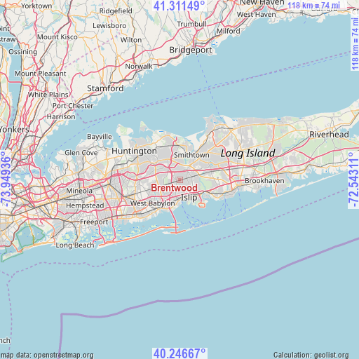
Brentwood GPS coordinates[2]
40° 46' 52.356" North, 73° 14' 46.428" West
| Map corner | latitude | longitude |
|---|---|---|
| Upper-left | 41.31149°, | -73.94936° |
| Center: | 40.78121°, | -73.24623° |
| Lower-right: | 40.24667°, | -72.54311° |
| Map W x H: | 118.4×118.4 km | = 73.6×73.6mi |
| max Lat: | 71.29058° ⇑37.2% North |
| Brentwood: | 40.78121° |
| min Lat: | ⇓62.8% South 19.06759° |
| min Long | Brentwood | max Long |
| -171.73463° | -73.24623° | -66.98998° |
| W 93.3%⇐ | ⇒6.7% E |
Elevation
Elevation of Brentwood is 26 m = 85 ft, and this is 268.8 m = 882 ft below average elevation for this country.
| Max E: |
3189 m = 10463 ft | 85.8% |
| Avg. | 294.8 m = 967 ft | |
| Brentwood | 26 m = 85 ft | |
Min E: |
-60 m = -197 ft | 14.2% |
See also: Brentwood elevation on elevation.city.
Geographical zone
Brentwood is located in North temperate zone (between Tropic of Cancer and the Arctic Circle). Distance of this Northern Tropic circle is 1928.5 km =1198.3 mi to South.| Distance of | km | miles | from Brentwood |
|---|---|---|---|
| North Pole | 5472.6 | 3400.5 | to North |
| Arctic Circle | 2866.7 | 1781.3 | to North |
| Tropic Cancer | 1928.5 | 1198.3 | to South |
| Equator | 4534.4 | 2817.5 | to South |


Nearby cities:
15 places around Brentwood: (largest is in red/bold)
• Bay Shore
6.2 km =3.9 mi,  179°
179°
• Bay Wood
5.1 km =3.2 mi,  227°
227°
• Brightwaters
6.9 km =4.3 mi,  194°
194°
• Central Islip
3.9 km =2.4 mi,  74°
74°
• Commack
7.9 km =4.9 mi,  330°
330°
• Deer Park
7.3 km =4.5 mi,  252°
252°
• Dix Hills
8 km =5 mi,  289°
289°
• East Islip
7.5 km =4.7 mi,  136°
136°
• Hauppauge
6.2 km =3.9 mi,  36°
36°
• Islandia
7 km =4.3 mi, 68°
• Islip
6.5 km =4 mi,  152°
152°
• Islip Terrace
6.2 km =3.9 mi,  133°
133°
• North Bay Shore
5.2 km =3.2 mi,  195°
195°
• North Great River
7.5 km =4.7 mi,  120°
120°
• West Bay Shore
8.6 km =5.3 mi, 200°
Sources, notices
• [Note1] Compared only with cities in United States existing in our database
• [Src1] Map data: © OpenStreetMap contributors (CC-BY-SA)
• [Src2] Other city data from geonames.org with taken over terms of usage.
• [Src3] Geographical zone / Annual Mean Temperature by Robert A. Rohde @ Wikipedia
