Canton geodata
Canton (New York) is a seat of a second-order administrative division; located in United States in America/New_York (GMT-4) time zone. With population of 6,570 people, there are 6067 cities with bigger population in this country. Compared to other cities in United States, 90.9% of cities are located further ↓South; 86.8% of cities are located further ←West and 67.9% of cities have higher elevation than Canton. Note1


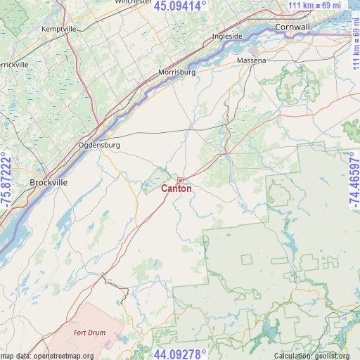
Canton GPS coordinates[2]
44° 35' 44.232" North, 75° 10' 8.724" West
| Map corner | latitude | longitude |
|---|---|---|
| Upper-left | 45.09414°, | -75.87222° |
| Center: | 44.59562°, | -75.16909° |
| Lower-right: | 44.09278°, | -74.46597° |
| Map W x H: | 111.3×111.3 km | = 69.2×69.2mi |
| max Lat: | 71.29058° ⇑9.1% North |
| Canton: | 44.59562° |
| min Lat: | ⇓90.9% South 19.06759° |
| min Long | Canton | max Long |
| -171.73463° | -75.16909° | -66.98998° |
| W 86.8%⇐ | ⇒13.2% E |
Elevation
Elevation of Canton is 113 m = 371 ft, and this is 181.8 m = 596 ft below average elevation for this country.
| Max E: |
3189 m = 10463 ft | 67.9% |
| Avg. | 294.8 m = 967 ft | |
| Canton | 113 m = 371 ft | |
Min E: |
-60 m = -197 ft | 32.1% |
See also: United States elevation on elevation.city.
Geographical zone
Canton is located in North temperate zone (between Tropic of Cancer and the Arctic Circle). Distance of this Northern Tropic circle is 2352.6 km =1461.8 mi to South.| Distance of | km | miles | from Canton |
|---|---|---|---|
| North Pole | 5048.5 | 3137 | to North |
| Arctic Circle | 2442.6 | 1517.8 | to North |
| Tropic Cancer | 2352.6 | 1461.8 | to South |
| Equator | 4958.6 | 3081.1 | to South |


Nearby cities:
15 places around Canton: (largest is in red/bold)
• Brasher Falls
39.1 km =24.3 mi,  52°
52°
• De Kalb Junction
13 km =8.1 mi,  219°
219°
• Gouverneur
37 km =23 mi, 219°
• Hailesboro
38.6 km =24 mi,  214°
214°
• Hannawa Falls
15.8 km =9.8 mi,  83°
83°
• Heuvelton
19 km =11.8 mi,  277°
277°
• Madrid
17.5 km =10.9 mi,  9°
9°
• Massena
43 km =26.7 mi,  30°
30°
• Norfolk
26.8 km =16.7 mi, 31°
• Norwood
22.2 km =13.8 mi,  38°
38°
• Ogdensburg
27.4 km =17 mi,  293°
293°
• Parishville
28.4 km =17.6 mi, 82°
• Potsdam
17 km =10.6 mi,  60°
60°
• Waddington
30 km =18.6 mi,  354°
354°
• Winthrop
37.5 km =23.3 mi, 53°
Sources, notices
• [Note1] Compared only with cities in United States existing in our database
• [Src1] Map data: © OpenStreetMap contributors (CC-BY-SA)
• [Src2] Other city data from geonames.org with taken over terms of usage.
• [Src3] Geographical zone / Annual Mean Temperature by Robert A. Rohde @ Wikipedia
