Cazenovia geodata
Cazenovia (New York) is a populated place; located in United States in America/New_York (GMT-4) time zone. With population of 2,855 people, there are 9899 cities with bigger population in this country. Compared to other cities in United States, 82.8% of cities are located further ↓South; 84.6% of cities are located further ←West and 81.8% of cities have lower elevation than Cazenovia. Note1


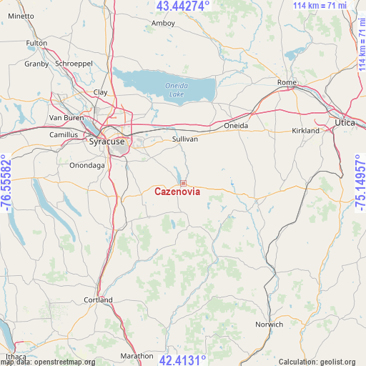
Cazenovia GPS coordinates[2]
42° 55' 48.252" North, 75° 51' 9.684" West
| Map corner | latitude | longitude |
|---|---|---|
| Upper-left | 43.44274°, | -76.55582° |
| Center: | 42.93007°, | -75.85269° |
| Lower-right: | 42.4131°, | -75.14957° |
| Map W x H: | 114.5×114.5 km | = 71.1×71.1mi |
| max Lat: | 71.29058° ⇑17.2% North |
| Cazenovia: | 42.93007° |
| min Lat: | ⇓82.8% South 19.06759° |
| min Long | Cazenovia | max Long |
| -171.73463° | -75.85269° | -66.98998° |
| W 84.6%⇐ | ⇒15.4% E |
Elevation
Elevation of Cazenovia is 374 m = 1227 ft, and this is 79.2 m = 260 ft above average elevation for this country.
| Max E: |
3189 m = 10463 ft | 18.2% |
| Cazenovia | 374 m 1227 ft | |
| Avg. | 294.8 m = 967 ft | |
Min E: |
-60 m = -197 ft | 81.8% |
See also: United States elevation on elevation.city.
Geographical zone
Cazenovia is located in North temperate zone (between Tropic of Cancer and the Arctic Circle). Distance of this Northern Tropic circle is 2167.5 km =1346.8 mi to South.| Distance of | km | miles | from Cazenovia |
|---|---|---|---|
| North Pole | 5233.7 | 3252.1 | to North |
| Arctic Circle | 2627.8 | 1632.8 | to North |
| Tropic Cancer | 2167.5 | 1346.8 | to South |
| Equator | 4773.4 | 2966.1 | to South |


Nearby cities:
15 places around Cazenovia: (largest is in red/bold)
• Bolivar
16 km =9.9 mi,  349°
349°
• Canastota
18.6 km =11.6 mi,  26°
26°
• Chittenango
12.8 km =8 mi, 354°
• DeRuyter
19.3 km =12 mi,  187°
187°
• Durhamville
25.8 km =16 mi, 34°
• East Syracuse
23.7 km =14.7 mi,  309°
309°
• Fayetteville
16.6 km =10.3 mi, 311°
• Manlius
12.9 km =8 mi, 308°
• Minoa
20.2 km =12.6 mi,  323°
323°
• Morrisville
17.7 km =11 mi,  101°
101°
• Nedrow
24 km =14.9 mi,  282°
282°
• Oneida
24.4 km =15.2 mi,  42°
42°
• Oneida Castle
24.6 km =15.3 mi,  46°
46°
• Tully
25.6 km =15.9 mi,  234°
234°
• Wampsville
20 km =12.4 mi, 36°
Sources, notices
• [Note1] Compared only with cities in United States existing in our database
• [Src1] Map data: © OpenStreetMap contributors (CC-BY-SA)
• [Src2] Other city data from geonames.org with taken over terms of usage.
• [Src3] Geographical zone / Annual Mean Temperature by Robert A. Rohde @ Wikipedia
