Dolgeville geodata
Dolgeville (New York) is a populated place; located in United States in America/New_York (GMT-4) time zone. With population of 2,132 people, there are 11525 cities with bigger population in this country. Compared to other cities in United States, 84.1% of cities are located further ↓South; 87.9% of cities are located further ←West and 61.2% of cities have lower elevation than Dolgeville. Note1


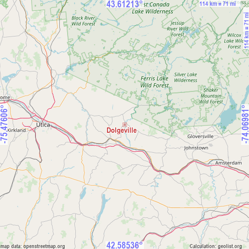
Dolgeville GPS coordinates[2]
43° 6' 3.24" North, 74° 46' 22.548" West
| Map corner | latitude | longitude |
|---|---|---|
| Upper-left | 43.61213°, | -75.47606° |
| Center: | 43.1009°, | -74.77293° |
| Lower-right: | 42.58536°, | -74.06981° |
| Map W x H: | 114.2×114.2 km | = 71×71mi |
| max Lat: | 71.29058° ⇑15.9% North |
| Dolgeville: | 43.1009° |
| min Lat: | ⇓84.1% South 19.06759° |
| min Long | Dolgeville | max Long |
| -171.73463° | -74.77293° | -66.98998° |
| W 87.9%⇐ | ⇒12.1% E |
Elevation
Elevation of Dolgeville is 245 m = 804 ft, and this is 49.8 m = 163 ft below average elevation for this country.
| Max E: |
3189 m = 10463 ft | 38.8% |
| Avg. | 294.8 m = 967 ft | |
| Dolgeville | 245 m = 804 ft | |
Min E: |
-60 m = -197 ft | 61.2% |
See also: United States elevation on elevation.city.
Geographical zone
Dolgeville is located in North temperate zone (between Tropic of Cancer and the Arctic Circle). Distance of this Northern Tropic circle is 2186.5 km =1358.6 mi to South.| Distance of | km | miles | from Dolgeville |
|---|---|---|---|
| North Pole | 5214.7 | 3240.3 | to North |
| Arctic Circle | 2608.8 | 1621 | to North |
| Tropic Cancer | 2186.5 | 1358.6 | to South |
| Equator | 4792.4 | 2977.9 | to South |


Nearby cities:
15 places around Dolgeville: (largest is in red/bold)
• Canajoharie
27.2 km =16.9 mi,  143°
143°
• Caroga Lake
24 km =14.9 mi,  80°
80°
• Fort Plain
22.5 km =14 mi,  147°
147°
• Frankfort
25.1 km =15.6 mi,  254°
254°
• Herkimer
19.2 km =11.9 mi,  244°
244°
• Ilion
23.4 km =14.5 mi, 245°
• Little Falls
9.5 km =5.9 mi,  227°
227°
• Middleville
16.4 km =10.2 mi,  284°
284°
• Mohawk
21.2 km =13.2 mi, 242°
• Nelliston
22.6 km =14 mi, 144°
• Newport
21.7 km =13.5 mi,  295°
295°
• Palatine Bridge
26.6 km =16.5 mi, 142°
• Richfield Springs
32.5 km =20.2 mi,  212°
212°
• Saint Johnsville
13.6 km =8.5 mi, 147°
• Springfield
30.2 km =18.8 mi,  192°
192°
Sources, notices
• [Note1] Compared only with cities in United States existing in our database
• [Src1] Map data: © OpenStreetMap contributors (CC-BY-SA)
• [Src2] Other city data from geonames.org with taken over terms of usage.
• [Src3] Geographical zone / Annual Mean Temperature by Robert A. Rohde @ Wikipedia
