East Patchogue geodata
East Patchogue (New York) is a populated place; located in United States in America/New_York (GMT-4) time zone. With population of 22,469 people, there are 2256 cities with bigger population in this country. Compared to other cities in United States, 62.6% of cities are located further ↓South; 93.9% of cities are located further ←West and 94.8% of cities have higher elevation than East Patchogue. Note1


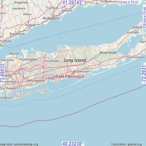
East Patchogue GPS coordinates[2]
40° 46' 1.344" North, 72° 59' 46.392" West
| Map corner | latitude | longitude |
|---|---|---|
| Upper-left | 41.29743°, | -73.69935° |
| Center: | 40.76704°, | -72.99622° |
| Lower-right: | 40.23238°, | -72.2931° |
| Map W x H: | 118.4×118.4 km | = 73.6×73.6mi |
| max Lat: | 71.29058° ⇑37.4% North |
| East Patchogue: | 40.76704° |
| min Lat: | ⇓62.6% South 19.06759° |
| min Long | East Patchogue | max Long |
| -171.73463° | -72.99622° | -66.98998° |
| W 93.9%⇐ | ⇒6.1% E |
Elevation
Elevation of East Patchogue is 9 m = 30 ft, and this is 285.8 m = 938 ft below average elevation for this country.
| Max E: |
3189 m = 10463 ft | 94.8% |
| Avg. | 294.8 m = 967 ft | |
| East Patchogue | 9 m = 30 ft | |
Min E: |
-60 m = -197 ft | 5.2% |
See also: United States elevation on elevation.city.
Geographical zone
East Patchogue is located in North temperate zone (between Tropic of Cancer and the Arctic Circle). Distance of this Northern Tropic circle is 1927 km =1197.4 mi to South.| Distance of | km | miles | from East Patchogue |
|---|---|---|---|
| North Pole | 5474.2 | 3401.5 | to North |
| Arctic Circle | 2868.3 | 1782.3 | to North |
| Tropic Cancer | 1927 | 1197.4 | to South |
| Equator | 4532.9 | 2816.6 | to South |


Nearby cities:
15 places around East Patchogue: (largest is in red/bold)
• Bayport
5.6 km =3.5 mi,  235°
235°
• Bellport
4.9 km =3 mi,  103°
103°
• Blue Point
4.1 km =2.5 mi,  231°
231°
• Bohemia
10 km =6.2 mi,  271°
271°
• Brookhaven
6.9 km =4.3 mi,  78°
78°
• Farmingville
7.7 km =4.8 mi,  338°
338°
• Holbrook
8.6 km =5.3 mi,  306°
306°
• Holtsville
6.8 km =4.2 mi,  322°
322°
• Medford
5.6 km =3.5 mi,  356°
356°
• North Bellport
4.6 km =2.9 mi, 79°
• North Patchogue
2.5 km =1.6 mi,  334°
334°
• Patchogue
1.6 km =1 mi,  264°
264°
• Sayville
8 km =5 mi, 244°
• West Sayville
9.6 km =6 mi, 242°
• Yaphank
10.2 km =6.3 mi,  40°
40°
Sources, notices
• [Note1] Compared only with cities in United States existing in our database
• [Src1] Map data: © OpenStreetMap contributors (CC-BY-SA)
• [Src2] Other city data from geonames.org with taken over terms of usage.
• [Src3] Geographical zone / Annual Mean Temperature by Robert A. Rohde @ Wikipedia
