Gardnertown geodata
Gardnertown (New York) is a populated place; located in United States in America/New_York (GMT-4) time zone. With population of 4,373 people, there are 7780 cities with bigger population in this country. Compared to other cities in United States, 71.2% of cities are located further ↓South; 90.1% of cities are located further ←West and 64.2% of cities have higher elevation than Gardnertown. Note1


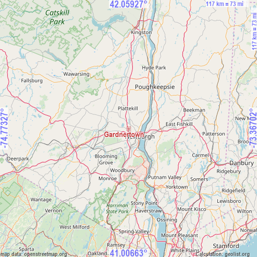
Gardnertown GPS coordinates[2]
41° 32' 6.324" North, 74° 4' 12.504" West
| Map corner | latitude | longitude |
|---|---|---|
| Upper-left | 42.05927°, | -74.77327° |
| Center: | 41.53509°, | -74.07014° |
| Lower-right: | 41.00663°, | -73.36702° |
| Map W x H: | 117×117 km | = 72.7×72.7mi |
| max Lat: | 71.29058° ⇑28.8% North |
| Gardnertown: | 41.53509° |
| min Lat: | ⇓71.2% South 19.06759° |
| min Long | Gardnertown | max Long |
| -171.73463° | -74.07014° | -66.98998° |
| W 90.1%⇐ | ⇒9.9% E |
Elevation
Elevation of Gardnertown is 132 m = 433 ft, and this is 162.8 m = 534 ft below average elevation for this country.
| Max E: |
3189 m = 10463 ft | 64.2% |
| Avg. | 294.8 m = 967 ft | |
| Gardnertown | 132 m = 433 ft | |
Min E: |
-60 m = -197 ft | 35.8% |
See also: United States elevation on elevation.city.
Geographical zone
Gardnertown is located in North temperate zone (between Tropic of Cancer and the Arctic Circle). Distance of this Northern Tropic circle is 2012.4 km =1250.4 mi to South.| Distance of | km | miles | from Gardnertown |
|---|---|---|---|
| North Pole | 5388.8 | 3348.4 | to North |
| Arctic Circle | 2782.9 | 1729.2 | to North |
| Tropic Cancer | 2012.4 | 1250.4 | to South |
| Equator | 4618.3 | 2869.7 | to South |


Nearby cities:
15 places around Gardnertown: (largest is in red/bold)
• Balmville
4.6 km =2.9 mi,  90°
90°
• Beacon
9 km =5.6 mi,  111°
111°
• Beaver Dam Lake
10.4 km =6.5 mi,  200°
200°
• Beaverdam Lake-Salisbury Mills
11.1 km =6.9 mi, 200°
• Cornwall
11 km =6.8 mi,  155°
155°
• Firthcliffe
10.9 km =6.8 mi,  168°
168°
• Marlboro
11.4 km =7.1 mi,  46°
46°
• New Windsor
7.5 km =4.7 mi,  149°
149°
• Newburgh
6.1 km =3.8 mi,  125°
125°
• Orange Lake
2.4 km =1.5 mi,  282°
282°
• Plattekill
9.2 km =5.7 mi,  356°
356°
• Salisbury Mills
12.3 km =7.6 mi, 199°
• Vails Gate
9 km =5.6 mi, 173°
• Walden
10.3 km =6.4 mi,  286°
286°
• Wallkill
12.3 km =7.6 mi,  309°
309°
Sources, notices
• [Note1] Compared only with cities in United States existing in our database
• [Src1] Map data: © OpenStreetMap contributors (CC-BY-SA)
• [Src2] Other city data from geonames.org with taken over terms of usage.
• [Src3] Geographical zone / Annual Mean Temperature by Robert A. Rohde @ Wikipedia
