Honeoye Falls geodata
Honeoye Falls (New York) is a populated place; located in United States in America/New_York (GMT-4) time zone. With population of 2,711 people, there are 10158 cities with bigger population in this country. Compared to other cities in United States, 82.9% of cities are located further ↓South; 78.6% of cities are located further ←West and 51.2% of cities have lower elevation than Honeoye Falls. Note1


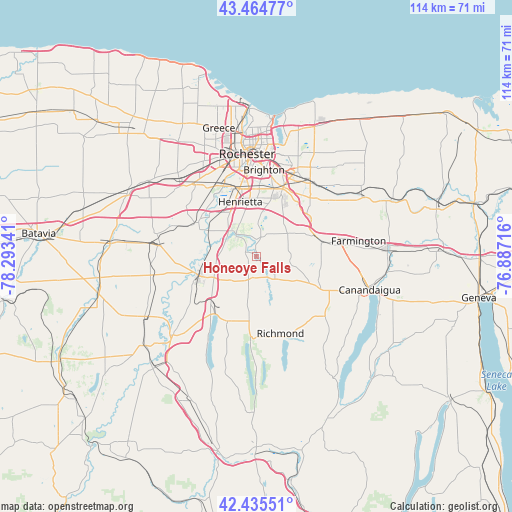
Honeoye Falls GPS coordinates[2]
42° 57' 8.244" North, 77° 35' 25.008" West
| Map corner | latitude | longitude |
|---|---|---|
| Upper-left | 43.46477°, | -78.29341° |
| Center: | 42.95229°, | -77.59028° |
| Lower-right: | 42.43551°, | -76.88716° |
| Map W x H: | 114.4×114.4 km | = 71.1×71.1mi |
| max Lat: | 71.29058° ⇑17.1% North |
| Honeoye Falls: | 42.95229° |
| min Lat: | ⇓82.9% South 19.06759° |
| min Long | Honeoye Falls | max Long |
| -171.73463° | -77.59028° | -66.98998° |
| W 78.6%⇐ | ⇒21.4% E |
Elevation
Elevation of Honeoye Falls is 203 m = 666 ft, and this is 91.8 m = 301 ft below average elevation for this country.
| Max E: |
3189 m = 10463 ft | 48.8% |
| Avg. | 294.8 m = 967 ft | |
| Honeoye Falls | 203 m = 666 ft | |
Min E: |
-60 m = -197 ft | 51.2% |
See also: United States elevation on elevation.city.
Geographical zone
Honeoye Falls is located in North temperate zone (between Tropic of Cancer and the Arctic Circle). Distance of this Northern Tropic circle is 2169.9 km =1348.3 mi to South.| Distance of | km | miles | from Honeoye Falls |
|---|---|---|---|
| North Pole | 5231.2 | 3250.5 | to North |
| Arctic Circle | 2625.3 | 1631.3 | to North |
| Tropic Cancer | 2169.9 | 1348.3 | to South |
| Equator | 4775.8 | 2967.5 | to South |


Nearby cities:
15 places around Honeoye Falls: (largest is in red/bold)
• Avon
13.4 km =8.3 mi,  250°
250°
• Brighton
22 km =13.7 mi,  8°
8°
• Caledonia
21.5 km =13.4 mi,  276°
276°
• East Avon
10.6 km =6.6 mi,  243°
243°
• East Rochester
19.3 km =12 mi,  25°
25°
• Fairport
20.3 km =12.6 mi,  36°
36°
• Hemlock
17.6 km =10.9 mi,  184°
184°
• Holcomb
15 km =9.3 mi,  111°
111°
• Honeoye
19 km =11.8 mi,  161°
161°
• Lakeville
15.9 km =9.9 mi,  215°
215°
• Lima
5.6 km =3.5 mi,  198°
198°
• Livonia
15.9 km =9.9 mi, 203°
• Pittsford
16.6 km =10.3 mi,  21°
21°
• Scottsville
15 km =9.3 mi,  302°
302°
• Victor
15.1 km =9.4 mi,  77°
77°
Sources, notices
• [Note1] Compared only with cities in United States existing in our database
• [Src1] Map data: © OpenStreetMap contributors (CC-BY-SA)
• [Src2] Other city data from geonames.org with taken over terms of usage.
• [Src3] Geographical zone / Annual Mean Temperature by Robert A. Rohde @ Wikipedia
