Jamaica geodata
Jamaica (New York) is a populated place; located in United States in America/New_York (GMT-4) time zone. With population of 216,866 people, there are 110 cities with bigger population in this country. Compared to other cities in United States, 61.5% of cities are located further ↓South; 91.6% of cities are located further ←West and 92.1% of cities have higher elevation than Jamaica. Note1


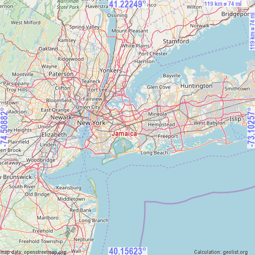
Jamaica GPS coordinates[2]
40° 41' 29.364" North, 73° 48' 20.484" West
| Map corner | latitude | longitude |
|---|---|---|
| Upper-left | 41.22249°, | -74.50882° |
| Center: | 40.69149°, | -73.80569° |
| Lower-right: | 40.15623°, | -73.10257° |
| Map W x H: | 118.6×118.6 km | = 73.7×73.7mi |
| max Lat: | 71.29058° ⇑38.5% North |
| Jamaica: | 40.69149° |
| min Lat: | ⇓61.5% South 19.06759° |
| min Long | Jamaica | max Long |
| -171.73463° | -73.80569° | -66.98998° |
| W 91.6%⇐ | ⇒8.4% E |
Elevation
Elevation of Jamaica is 12 m = 39 ft, and this is 282.8 m = 928 ft below average elevation for this country.
| Max E: |
3189 m = 10463 ft | 92.1% |
| Avg. | 294.8 m = 967 ft | |
| Jamaica | 12 m = 39 ft | |
Min E: |
-60 m = -197 ft | 7.9% |
See also: Jamaica elevation on elevation.city.
Geographical zone
Jamaica is located in North temperate zone (between Tropic of Cancer and the Arctic Circle). Distance of this Northern Tropic circle is 1918.6 km =1192.2 mi to South.| Distance of | km | miles | from Jamaica |
|---|---|---|---|
| North Pole | 5482.6 | 3406.7 | to North |
| Arctic Circle | 2876.7 | 1787.5 | to North |
| Tropic Cancer | 1918.6 | 1192.2 | to South |
| Equator | 4524.5 | 2811.4 | to South |


Nearby cities:
15 places around Jamaica: (largest is in red/bold)
• Bellaire
5 km =3.1 mi,  60°
60°
• Briarwood
2.1 km =1.3 mi,  337°
337°
• Forest Hills
4.6 km =2.9 mi,  306°
306°
• Fresh Meadows
4.9 km =3 mi,  12°
12°
• Hillside
2.4 km =1.5 mi,  41°
41°
• Hollis
4.1 km =2.5 mi,  53°
53°
• Howard Beach
4.5 km =2.8 mi,  214°
214°
• Kew Gardens
3.3 km =2.1 mi,  319°
319°
• Kew Gardens Hills
4.5 km =2.8 mi, 340°
• Ozone Park
3.6 km =2.2 mi,  242°
242°
• Queens
2.8 km =1.7 mi,  246°
246°
• Richmond Hill
2.3 km =1.4 mi,  293°
293°
• Springfield Gardens
4.8 km =3 mi,  130°
130°
• Terrace Heights
4.5 km =2.8 mi, 42°
• Woodhaven
4.4 km =2.7 mi,  266°
266°
Sources, notices
• [Note1] Compared only with cities in United States existing in our database
• [Src1] Map data: © OpenStreetMap contributors (CC-BY-SA)
• [Src2] Other city data from geonames.org with taken over terms of usage.
• [Src3] Geographical zone / Annual Mean Temperature by Robert A. Rohde @ Wikipedia
