Marbletown geodata
Marbletown (New York) is a populated place; located in United States in America/New_York (GMT-4) time zone. With population of 5,544 people, there are 6727 cities with bigger population in this country. Compared to other cities in United States, 74.6% of cities are located further ↓South; 89.9% of cities are located further ←West and 75.6% of cities have higher elevation than Marbletown. Note1


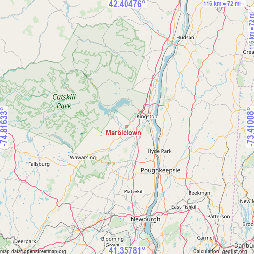
Marbletown GPS coordinates[2]
41° 53' 0.348" North, 74° 6' 47.52" West
| Map corner | latitude | longitude |
|---|---|---|
| Upper-left | 42.40476°, | -74.81633° |
| Center: | 41.88343°, | -74.1132° |
| Lower-right: | 41.35781°, | -73.41008° |
| Map W x H: | 116.4×116.4 km | = 72.3×72.3mi |
| max Lat: | 71.29058° ⇑25.4% North |
| Marbletown: | 41.88343° |
| min Lat: | ⇓74.6% South 19.06759° |
| min Long | Marbletown | max Long |
| -171.73463° | -74.1132° | -66.98998° |
| W 89.9%⇐ | ⇒10.1% E |
Elevation
Elevation of Marbletown is 68 m = 223 ft, and this is 226.8 m = 744 ft below average elevation for this country.
| Max E: |
3189 m = 10463 ft | 75.6% |
| Avg. | 294.8 m = 967 ft | |
| Marbletown | 68 m = 223 ft | |
Min E: |
-60 m = -197 ft | 24.4% |
See also: United States elevation on elevation.city.
Geographical zone
Marbletown is located in North temperate zone (between Tropic of Cancer and the Arctic Circle). Distance of this Northern Tropic circle is 2051.1 km =1274.5 mi to South.| Distance of | km | miles | from Marbletown |
|---|---|---|---|
| North Pole | 5350.1 | 3324.4 | to North |
| Arctic Circle | 2744.2 | 1705.2 | to North |
| Tropic Cancer | 2051.1 | 1274.5 | to South |
| Equator | 4657 | 2893.7 | to South |


Nearby cities:
15 places around Marbletown: (largest is in red/bold)
• Accord
14.5 km =9 mi,  221°
221°
• High Falls
6.4 km =4 mi,  189°
189°
• Hillside
7.5 km =4.7 mi,  59°
59°
• Hurley
6.3 km =3.9 mi,  43°
43°
• Kingston
10.7 km =6.6 mi, 63°
• Lake Katrine
15.4 km =9.6 mi, 42°
• Lincoln Park
12.4 km =7.7 mi,  52°
52°
• New Paltz
15.3 km =9.5 mi,  171°
171°
• Port Ewen
11.6 km =7.2 mi,  77°
77°
• Rosendale Village
4.9 km =3 mi,  138°
138°
• Shokan
12.9 km =8 mi,  320°
320°
• Stone Ridge
4 km =2.5 mi,  212°
212°
• Tillson
7.1 km =4.4 mi,  148°
148°
• West Hurley
12.7 km =7.9 mi,  3°
3°
• Zena
15.1 km =9.4 mi,  11°
11°
Sources, notices
• [Note1] Compared only with cities in United States existing in our database
• [Src1] Map data: © OpenStreetMap contributors (CC-BY-SA)
• [Src2] Other city data from geonames.org with taken over terms of usage.
• [Src3] Geographical zone / Annual Mean Temperature by Robert A. Rohde @ Wikipedia
