Melville geodata
Melville (New York) is a populated place; located in United States in America/New_York (GMT-4) time zone. With population of 18,985 people, there are 2656 cities with bigger population in this country. Compared to other cities in United States, 63% of cities are located further ↓South; 93% of cities are located further ←West and 80.6% of cities have higher elevation than Melville. Note1


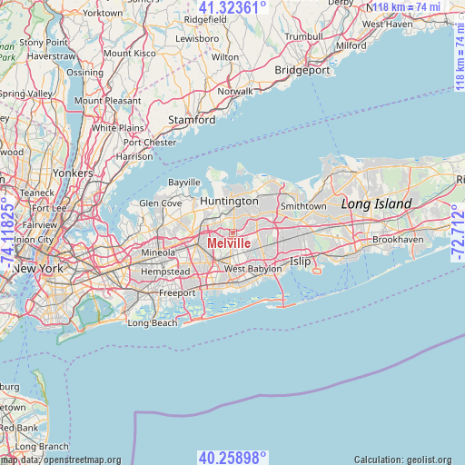
Melville GPS coordinates[2]
40° 47' 36.348" North, 73° 24' 54.432" West
| Map corner | latitude | longitude |
|---|---|---|
| Upper-left | 41.32361°, | -74.11825° |
| Center: | 40.79343°, | -73.41512° |
| Lower-right: | 40.25898°, | -72.712° |
| Map W x H: | 118.4×118.4 km | = 73.6×73.6mi |
| max Lat: | 71.29058° ⇑37% North |
| Melville: | 40.79343° |
| min Lat: | ⇓63% South 19.06759° |
| min Long | Melville | max Long |
| -171.73463° | -73.41512° | -66.98998° |
| W 93%⇐ | ⇒7% E |
Elevation
Elevation of Melville is 44 m = 144 ft, and this is 250.8 m = 823 ft below average elevation for this country.
| Max E: |
3189 m = 10463 ft | 80.6% |
| Avg. | 294.8 m = 967 ft | |
| Melville | 44 m = 144 ft | |
Min E: |
-60 m = -197 ft | 19.4% |
See also: United States elevation on elevation.city.
Geographical zone
Melville is located in North temperate zone (between Tropic of Cancer and the Arctic Circle). Distance of this Northern Tropic circle is 1929.9 km =1199.2 mi to South.| Distance of | km | miles | from Melville |
|---|---|---|---|
| North Pole | 5471.3 | 3399.7 | to North |
| Arctic Circle | 2865.4 | 1780.5 | to North |
| Tropic Cancer | 1929.9 | 1199.2 | to South |
| Equator | 4535.8 | 2818.4 | to South |


Nearby cities:
15 places around Melville: (largest is in red/bold)
• Bethpage
7.9 km =4.9 mi,  225°
225°
• Deer Park
8 km =5 mi,  115°
115°
• Dix Hills
6.8 km =4.2 mi,  79°
79°
• East Farmingdale
7.1 km =4.4 mi,  181°
181°
• Farmingdale
7.2 km =4.5 mi,  200°
200°
• Huntington Station
6.7 km =4.2 mi,  2°
2°
• Old Bethpage
4.7 km =2.9 mi,  223°
223°
• Plainview
4.8 km =3 mi,  246°
246°
• South Farmingdale
8.4 km =5.2 mi,  194°
194°
• South Huntington
3.6 km =2.2 mi,  22°
22°
• Syosset
8.2 km =5.1 mi,  296°
296°
• West Hills
2.9 km =1.8 mi,  330°
330°
• Wheatley Heights
5 km =3.1 mi,  130°
130°
• Woodbury
5.7 km =3.5 mi,  309°
309°
• Wyandanch
6.4 km =4 mi, 133°
Sources, notices
• [Note1] Compared only with cities in United States existing in our database
• [Src1] Map data: © OpenStreetMap contributors (CC-BY-SA)
• [Src2] Other city data from geonames.org with taken over terms of usage.
• [Src3] Geographical zone / Annual Mean Temperature by Robert A. Rohde @ Wikipedia
