Oyster Bay geodata
Oyster Bay (New York) is a populated place; located in United States in America/New_York (GMT-4) time zone. With population of 6,707 people, there are 5972 cities with bigger population in this country. Compared to other cities in United States, 64.2% of cities are located further ↓South; 92.7% of cities are located further ←West and 91% of cities have higher elevation than Oyster Bay. Note1


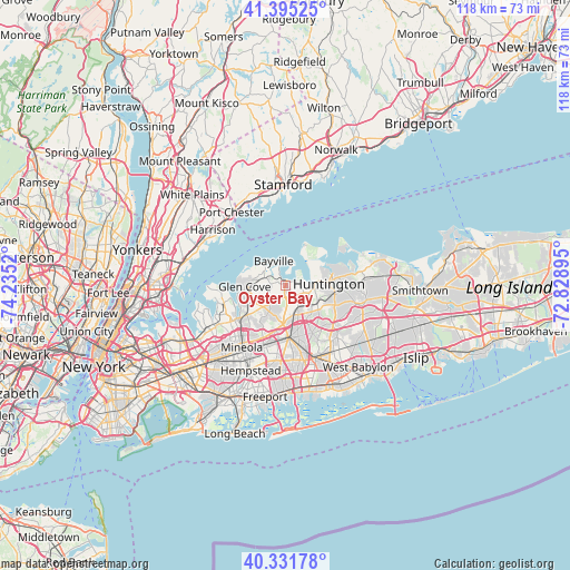
Oyster Bay GPS coordinates[2]
40° 51' 56.34" North, 73° 31' 55.452" West
| Map corner | latitude | longitude |
|---|---|---|
| Upper-left | 41.39525°, | -74.2352° |
| Center: | 40.86565°, | -73.53207° |
| Lower-right: | 40.33178°, | -72.82895° |
| Map W x H: | 118.2×118.2 km | = 73.4×73.4mi |
| max Lat: | 71.29058° ⇑35.8% North |
| Oyster Bay: | 40.86565° |
| min Lat: | ⇓64.2% South 19.06759° |
| min Long | Oyster Bay | max Long |
| -171.73463° | -73.53207° | -66.98998° |
| W 92.7%⇐ | ⇒7.3% E |
Elevation
Elevation of Oyster Bay is 14 m = 46 ft, and this is 280.8 m = 921 ft below average elevation for this country.
| Max E: |
3189 m = 10463 ft | 91% |
| Avg. | 294.8 m = 967 ft | |
| Oyster Bay | 14 m = 46 ft | |
Min E: |
-60 m = -197 ft | 9% |
See also: United States elevation on elevation.city.
Geographical zone
Oyster Bay is located in North temperate zone (between Tropic of Cancer and the Arctic Circle). Distance of this Northern Tropic circle is 1937.9 km =1204.2 mi to South.| Distance of | km | miles | from Oyster Bay |
|---|---|---|---|
| North Pole | 5463.2 | 3394.7 | to North |
| Arctic Circle | 2857.3 | 1775.4 | to North |
| Tropic Cancer | 1937.9 | 1204.2 | to South |
| Equator | 4543.8 | 2823.4 | to South |


Nearby cities:
15 places around Oyster Bay: (largest is in red/bold)
• Bayville
5.6 km =3.5 mi,  333°
333°
• Brookville
6.5 km =4 mi,  206°
206°
• Cold Spring Harbor
6.4 km =4 mi,  84°
84°
• East Norwich
2.1 km =1.3 mi,  186°
186°
• Lattingtown
6.7 km =4.2 mi,  299°
299°
• Laurel Hollow
5.3 km =3.3 mi,  100°
100°
• Locust Valley
5.6 km =3.5 mi,  281°
281°
• Matinecock
3.9 km =2.4 mi,  287°
287°
• Mill Neck
3.1 km =1.9 mi,  320°
320°
• Muttontown
4.8 km =3 mi,  195°
195°
• Old Brookville
7.2 km =4.5 mi,  238°
238°
• Oyster Bay Cove
1.9 km =1.2 mi,  71°
71°
• Syosset
5.1 km =3.2 mi,  150°
150°
• Upper Brookville
4.1 km =2.5 mi,  222°
222°
• Woodbury
7 km =4.3 mi,  129°
129°
Sources, notices
• [Note1] Compared only with cities in United States existing in our database
• [Src1] Map data: © OpenStreetMap contributors (CC-BY-SA)
• [Src2] Other city data from geonames.org with taken over terms of usage.
• [Src3] Geographical zone / Annual Mean Temperature by Robert A. Rohde @ Wikipedia
