Port Washington geodata
Port Washington (New York) is a populated place; located in United States in America/New_York (GMT-4) time zone. With population of 15,846 people, there are 3091 cities with bigger population in this country. Compared to other cities in United States, 63.6% of cities are located further ↓South; 92.1% of cities are located further ←West and 83.6% of cities have higher elevation than Port Washington. Note1
Administrative division(s):
- Level 1: New York
- Level 2: Nassau County
- Level 3: Town of North Hempstead


Port Washington GPS coordinates[2]
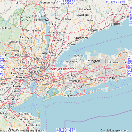
40° 49' 32.376" North, 73° 41' 53.484" West
| Map corner | latitude | longitude |
|---|---|---|
| Upper-left | 41.35558°, | -74.40132° |
| Center: | 40.82566°, | -73.69819° |
| Lower-right: | 40.29147°, | -72.99507° |
| Map W x H: | 118.3×118.3 km | = 73.5×73.5mi |
| max Lat: | 71.29058° ⇑36.4% North |
| Port Washington: | 40.82566° |
| min Lat: | ⇓63.6% South 19.06759° |
| min Long | Port Washington | max Long |
| -171.73463° | -73.69819° | -66.98998° |
| W 92.1%⇐ | ⇒7.9% E |
Elevation
Elevation of Port Washington is 33 m = 108 ft, and this is 261.8 m = 859 ft below average elevation for this country.
| Max E: |
3189 m = 10463 ft | 83.6% |
| Avg. | 294.8 m = 967 ft | |
| Port Washington | 33 m = 108 ft | |
Min E: |
-60 m = -197 ft | 16.4% |
See also: United States elevation on elevation.city.
Geographical zone
Port Washington is located in North temperate zone (between Tropic of Cancer and the Arctic Circle). Distance of this Northern Tropic circle is 1933.5 km =1201.4 mi to South.| Distance of | km | miles | from Port Washington |
|---|---|---|---|
| North Pole | 5467.7 | 3397.5 | to North |
| Arctic Circle | 2861.8 | 1778.2 | to North |
| Tropic Cancer | 1933.5 | 1201.4 | to South |
| Equator | 4539.4 | 2820.7 | to South |


Nearby cities:
15 places around Port Washington: (largest is in red/bold)
• Baxter Estates
1 km =0.6 mi,  12°
12°
• Flower Hill
2.5 km =1.6 mi,  145°
145°
• Great Neck
3.8 km =2.4 mi,  222°
222°
• Great Neck Gardens
3.8 km =2.4 mi,  214°
214°
• Kensington
4.1 km =2.5 mi, 209°
• Kings Point
3.2 km =2 mi,  258°
258°
• Manhasset
3.1 km =1.9 mi,  182°
182°
• Manorhaven
2.4 km =1.5 mi,  324°
324°
• Munsey Park
3.4 km =2.1 mi, 152°
• Plandome
2.1 km =1.3 mi,  191°
191°
• Plandome Heights
2.6 km =1.6 mi, 191°
• Plandome Manor
1.1 km =0.7 mi, 176°
• Port Washington North
2.2 km =1.4 mi,  351°
351°
• Sands Point
3.4 km =2.1 mi,  329°
329°
• Thomaston
4.6 km =2.9 mi,  196°
196°
Sources, notices
• [Note1] Compared only with cities in United States existing in our database
• [Src1] Map data: © OpenStreetMap contributors (CC-BY-SA)
• [Src2] Other city data from geonames.org with taken over terms of usage.
• [Src3] Geographical zone / Annual Mean Temperature by Robert A. Rohde @ Wikipedia
