Shoreham geodata
Shoreham (New York) is a populated place; located in United States in America/New_York (GMT-4) time zone. With population of 535 people, there are 20452 cities with bigger population in this country. Compared to other cities in United States, 65.4% of cities are located further ↓South; 94.1% of cities are located further ←West and 85.4% of cities have higher elevation than Shoreham. Note1


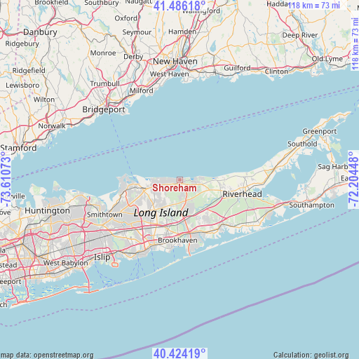
Shoreham GPS coordinates[2]
40° 57' 26.352" North, 72° 54' 27.36" West
| Map corner | latitude | longitude |
|---|---|---|
| Upper-left | 41.48618°, | -73.61073° |
| Center: | 40.95732°, | -72.9076° |
| Lower-right: | 40.42419°, | -72.20448° |
| Map W x H: | 118.1×118.1 km | = 73.4×73.4mi |
| max Lat: | 71.29058° ⇑34.6% North |
| Shoreham: | 40.95732° |
| min Lat: | ⇓65.4% South 19.06759° |
| min Long | Shoreham | max Long |
| -171.73463° | -72.9076° | -66.98998° |
| W 94.1%⇐ | ⇒5.9% E |
Elevation
Elevation of Shoreham is 27 m = 89 ft, and this is 267.8 m = 879 ft below average elevation for this country.
| Max E: |
3189 m = 10463 ft | 85.4% |
| Avg. | 294.8 m = 967 ft | |
| Shoreham | 27 m = 89 ft | |
Min E: |
-60 m = -197 ft | 14.6% |
See also: United States elevation on elevation.city.
Geographical zone
Shoreham is located in North temperate zone (between Tropic of Cancer and the Arctic Circle). Distance of this Northern Tropic circle is 1948.1 km =1210.5 mi to South.| Distance of | km | miles | from Shoreham |
|---|---|---|---|
| North Pole | 5453 | 3388.3 | to North |
| Arctic Circle | 2847.1 | 1769.1 | to North |
| Tropic Cancer | 1948.1 | 1210.5 | to South |
| Equator | 4554 | 2829.7 | to South |


Nearby cities:
15 places around Shoreham: (largest is in red/bold)
• Belle Terre
13.5 km =8.4 mi,  271°
271°
• Coram
12.6 km =7.8 mi,  218°
218°
• East Shoreham
2.7 km =1.7 mi,  120°
120°
• Gordon Heights
12.2 km =7.6 mi,  205°
205°
• Manorville
12.5 km =7.8 mi,  137°
137°
• Middle Island
8.5 km =5.3 mi,  197°
197°
• Miller Place
7.4 km =4.6 mi, 272°
• Mount Sinai
10.3 km =6.4 mi,  263°
263°
• Port Jefferson
13.6 km =8.5 mi, 264°
• Port Jefferson Station
12.3 km =7.6 mi,  253°
253°
• Ridge
7.1 km =4.4 mi,  172°
172°
• Rocky Point
1.6 km =1 mi, 250°
• Sound Beach
5.1 km =3.2 mi, 268°
• Wading River
5.5 km =3.4 mi,  98°
98°
• Yaphank
13.4 km =8.3 mi,  183°
183°
Sources, notices
• [Note1] Compared only with cities in United States existing in our database
• [Src1] Map data: © OpenStreetMap contributors (CC-BY-SA)
• [Src2] Other city data from geonames.org with taken over terms of usage.
• [Src3] Geographical zone / Annual Mean Temperature by Robert A. Rohde @ Wikipedia
