Southold geodata
Southold (New York) is a populated place; located in United States in America/New_York (GMT-4) time zone. With population of 5,748 people, there are 6574 cities with bigger population in this country. Compared to other cities in United States, 66.6% of cities are located further ↓South; 95% of cities are located further ←West and 93% of cities have higher elevation than Southold. Note1


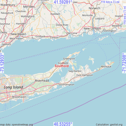
Southold GPS coordinates[2]
41° 3' 53.352" North, 72° 25' 34.32" West
| Map corner | latitude | longitude |
|---|---|---|
| Upper-left | 41.59281°, | -73.12933° |
| Center: | 41.06482°, | -72.4262° |
| Lower-right: | 40.53255°, | -71.72308° |
| Map W x H: | 117.9×117.9 km | = 73.3×73.3mi |
| max Lat: | 71.29058° ⇑33.4% North |
| Southold: | 41.06482° |
| min Lat: | ⇓66.6% South 19.06759° |
| min Long | Southold | max Long |
| -171.73463° | -72.4262° | -66.98998° |
| W 95%⇐ | ⇒5% E |
Elevation
Elevation of Southold is 11 m = 36 ft, and this is 283.8 m = 931 ft below average elevation for this country.
| Max E: |
3189 m = 10463 ft | 93% |
| Avg. | 294.8 m = 967 ft | |
| Southold | 11 m = 36 ft | |
Min E: |
-60 m = -197 ft | 7% |
See also: United States elevation on elevation.city.
Geographical zone
Southold is located in North temperate zone (between Tropic of Cancer and the Arctic Circle). Distance of this Northern Tropic circle is 1960.1 km =1217.9 mi to South.| Distance of | km | miles | from Southold |
|---|---|---|---|
| North Pole | 5441.1 | 3380.9 | to North |
| Arctic Circle | 2835.2 | 1761.7 | to North |
| Tropic Cancer | 1960.1 | 1217.9 | to South |
| Equator | 4566 | 2837.2 | to South |


Nearby cities:
15 places around Southold: (largest is in red/bold)
• Bridgehampton
17.6 km =10.9 mi,  143°
143°
• Cutchogue
7.8 km =4.8 mi,  219°
219°
• East Marion
10 km =6.2 mi,  45°
45°
• Greenport
7.1 km =4.4 mi, 52°
• Greenport West
6.1 km =3.8 mi, 47°
• Laurel
15.6 km =9.7 mi,  227°
227°
• Mattituck
12.2 km =7.6 mi, 227°
• North Haven
11.1 km =6.9 mi,  121°
121°
• North Sea
14.7 km =9.1 mi,  176°
176°
• Noyack
10.5 km =6.5 mi, 137°
• Orient
13.2 km =8.2 mi, 51°
• Peconic
3.6 km =2.2 mi,  238°
238°
• Sag Harbor
13.5 km =8.4 mi, 123°
• Shelter Island
7.3 km =4.5 mi,  87°
87°
• Shelter Island Heights
6.3 km =3.9 mi,  70°
70°
Sources, notices
• [Note1] Compared only with cities in United States existing in our database
• [Src1] Map data: © OpenStreetMap contributors (CC-BY-SA)
• [Src2] Other city data from geonames.org with taken over terms of usage.
• [Src3] Geographical zone / Annual Mean Temperature by Robert A. Rohde @ Wikipedia
