Staten Island geodata
Staten Island (New York) is a seat of a second-order administrative division; located in United States in America/New_York (GMT-4) time zone. With population of 468,730 people, there are 43 cities with bigger population in this country. Compared to other cities in United States, 59.5% of cities are located further ↓South; 89.8% of cities are located further ←West and 87% of cities have higher elevation than Staten Island. Note1


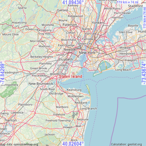
Staten Island GPS coordinates[2]
40° 33' 44.388" North, 74° 8' 23.496" West
| Map corner | latitude | longitude |
|---|---|---|
| Upper-left | 41.09436°, | -74.84299° |
| Center: | 40.56233°, | -74.13986° |
| Lower-right: | 40.02604°, | -73.43674° |
| Map W x H: | 118.8×118.8 km | = 73.8×73.8mi |
| max Lat: | 71.29058° ⇑40.5% North |
| Staten Island: | 40.56233° |
| min Lat: | ⇓59.5% South 19.06759° |
| min Long | Staten Island | max Long |
| -171.73463° | -74.13986° | -66.98998° |
| W 89.8%⇐ | ⇒10.2% E |
Elevation
Elevation of Staten Island is 23 m = 75 ft, and this is 271.8 m = 892 ft below average elevation for this country.
| Max E: |
3189 m = 10463 ft | 87% |
| Avg. | 294.8 m = 967 ft | |
| Staten Island | 23 m = 75 ft | |
Min E: |
-60 m = -197 ft | 13% |
See also: Staten Island elevation on elevation.city.
Geographical zone
Staten Island is located in North temperate zone (between Tropic of Cancer and the Arctic Circle). Distance of this Northern Tropic circle is 1904.2 km =1183.2 mi to South.| Distance of | km | miles | from Staten Island |
|---|---|---|---|
| North Pole | 5497 | 3415.7 | to North |
| Arctic Circle | 2891.1 | 1796.4 | to North |
| Tropic Cancer | 1904.2 | 1183.2 | to South |
| Equator | 4510.1 | 2802.4 | to South |


Nearby cities:
15 places around Staten Island: (largest is in red/bold)
• Chelsea
6.3 km =3.9 mi,  312°
312°
• Dongan Hills
4.7 km =2.9 mi,  51°
51°
• Eltingville
2.9 km =1.8 mi,  229°
229°
• Grant City
3.7 km =2.3 mi, 53°
• Great Kills
1.3 km =0.8 mi, 227°
• Huguenot
5.4 km =3.4 mi,  238°
238°
• Midland Beach
4 km =2.5 mi,  72°
72°
• New Dorp
2.4 km =1.5 mi,  57°
57°
• New Dorp Beach
3.1 km =1.9 mi,  83°
83°
• New Springville
4 km =2.5 mi,  330°
330°
• Oakwood
2 km =1.2 mi, 84°
• Rossville
6.3 km =3.9 mi,  263°
263°
• South Beach
5.9 km =3.7 mi, 66°
• Willowbrook
4.5 km =2.8 mi,  1°
1°
• Woodrow
5.3 km =3.3 mi,  246°
246°
Sources, notices
• [Note1] Compared only with cities in United States existing in our database
• [Src1] Map data: © OpenStreetMap contributors (CC-BY-SA)
• [Src2] Other city data from geonames.org with taken over terms of usage.
• [Src3] Geographical zone / Annual Mean Temperature by Robert A. Rohde @ Wikipedia
