Utica geodata
Utica (New York) is a seat of a second-order administrative division; located in United States in America/New_York (GMT-4) time zone. With population of 61,100 people, there are 718 cities with bigger population in this country. Compared to other cities in United States, 84.1% of cities are located further ↓South; 86.6% of cities are located further ←West and 62.2% of cities have higher elevation than Utica. Note1


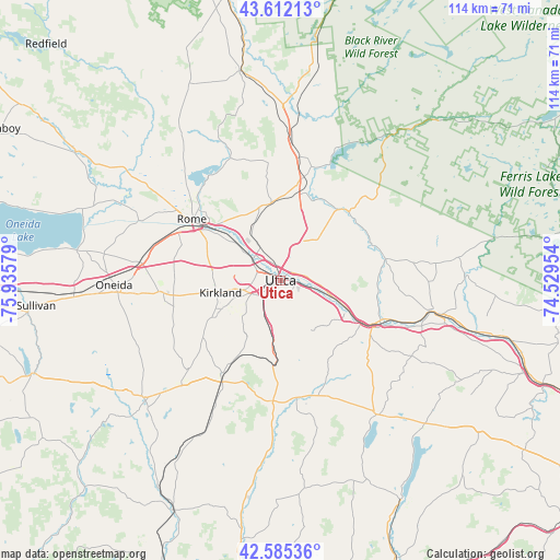
Utica GPS coordinates[2]
43° 6' 3.24" North, 75° 13' 57.576" West
| Map corner | latitude | longitude |
|---|---|---|
| Upper-left | 43.61213°, | -75.93579° |
| Center: | 43.1009°, | -75.23266° |
| Lower-right: | 42.58536°, | -74.52954° |
| Map W x H: | 114.2×114.2 km | = 71×71mi |
| max Lat: | 71.29058° ⇑15.9% North |
| Utica: | 43.1009° |
| min Lat: | ⇓84.1% South 19.06759° |
| min Long | Utica | max Long |
| -171.73463° | -75.23266° | -66.98998° |
| W 86.6%⇐ | ⇒13.4% E |
Elevation
Elevation of Utica is 143 m = 469 ft, and this is 151.8 m = 498 ft below average elevation for this country.
| Max E: |
3189 m = 10463 ft | 62.2% |
| Avg. | 294.8 m = 967 ft | |
| Utica | 143 m = 469 ft | |
Min E: |
-60 m = -197 ft | 37.8% |
See also: Utica elevation on elevation.city.
Geographical zone
Utica is located in North temperate zone (between Tropic of Cancer and the Arctic Circle). Distance of this Northern Tropic circle is 2186.5 km =1358.6 mi to South.| Distance of | km | miles | from Utica |
|---|---|---|---|
| North Pole | 5214.7 | 3240.3 | to North |
| Arctic Circle | 2608.8 | 1621 | to North |
| Tropic Cancer | 2186.5 | 1358.6 | to South |
| Equator | 4792.4 | 2977.9 | to South |


Nearby cities:
15 places around Utica: (largest is in red/bold)
• Chadwicks
8.7 km =5.4 mi,  201°
201°
• Clark Mills
12 km =7.5 mi,  265°
265°
• Clinton
13.2 km =8.2 mi,  243°
243°
• Frankfort
14.9 km =9.3 mi,  117°
117°
• Herkimer
21.7 km =13.5 mi,  112°
112°
• Ilion
18.7 km =11.6 mi, 120°
• Middleville
21.9 km =13.6 mi,  78°
78°
• Mohawk
21.1 km =13.1 mi, 118°
• New Hartford
5.4 km =3.4 mi, 235°
• New York Mills
4.8 km =3 mi,  275°
275°
• Newport
20.1 km =12.5 mi,  61°
61°
• Oriskany
10.3 km =6.4 mi,  307°
307°
• Washington Mills
6.5 km =4 mi,  210°
210°
• Whitesboro
5.3 km =3.3 mi,  296°
296°
• Yorkville
3.4 km =2.1 mi,  293°
293°
Sources, notices
• [Note1] Compared only with cities in United States existing in our database
• [Src1] Map data: © OpenStreetMap contributors (CC-BY-SA)
• [Src2] Other city data from geonames.org with taken over terms of usage.
• [Src3] Geographical zone / Annual Mean Temperature by Robert A. Rohde @ Wikipedia
