West Point geodata
West Point (New York) is a populated place; located in United States in America/New_York (GMT-4) time zone. With population of 6,763 people, there are 5947 cities with bigger population in this country. Compared to other cities in United States, 69.7% of cities are located further ↓South; 90.9% of cities are located further ←West and 78.4% of cities have higher elevation than West Point. Note1


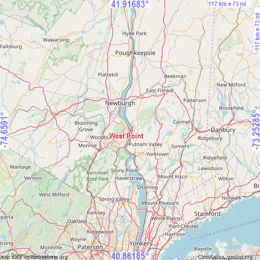
West Point GPS coordinates[2]
41° 23' 29.328" North, 73° 57' 21.492" West
| Map corner | latitude | longitude |
|---|---|---|
| Upper-left | 41.91683°, | -74.6591° |
| Center: | 41.39148°, | -73.95597° |
| Lower-right: | 40.86185°, | -73.25285° |
| Map W x H: | 117.3×117.3 km | = 72.9×72.9mi |
| max Lat: | 71.29058° ⇑30.3% North |
| West Point: | 41.39148° |
| min Lat: | ⇓69.7% South 19.06759° |
| min Long | West Point | max Long |
| -171.73463° | -73.95597° | -66.98998° |
| W 90.9%⇐ | ⇒9.1% E |
Elevation
Elevation of West Point is 54 m = 177 ft, and this is 240.8 m = 790 ft below average elevation for this country.
| Max E: |
3189 m = 10463 ft | 78.4% |
| Avg. | 294.8 m = 967 ft | |
| West Point | 54 m = 177 ft | |
Min E: |
-60 m = -197 ft | 21.6% |
See also: United States elevation on elevation.city.
Geographical zone
West Point is located in North temperate zone (between Tropic of Cancer and the Arctic Circle). Distance of this Northern Tropic circle is 1996.4 km =1240.5 mi to South.| Distance of | km | miles | from West Point |
|---|---|---|---|
| North Pole | 5404.8 | 3358.4 | to North |
| Arctic Circle | 2798.9 | 1739.2 | to North |
| Tropic Cancer | 1996.4 | 1240.5 | to South |
| Equator | 4602.3 | 2859.7 | to South |


Nearby cities:
15 places around West Point: (largest is in red/bold)
• Beacon
12.7 km =7.9 mi,  354°
354°
• Cold Spring
3.2 km =2 mi,  2°
2°
• Cornwall
7.7 km =4.8 mi,  319°
319°
• Crompond
13.1 km =8.1 mi,  144°
144°
• Firthcliffe
9.1 km =5.7 mi,  305°
305°
• Fort Montgomery
7.2 km =4.5 mi,  201°
201°
• Highland Falls
2.6 km =1.6 mi, 199°
• Lake Mohegan
12.3 km =7.6 mi,  131°
131°
• Nelsonville
3.8 km =2.4 mi,  12°
12°
• New Windsor
11 km =6.8 mi,  329°
329°
• Newburgh
13.2 km =8.2 mi,  339°
339°
• Peekskill
11.7 km =7.3 mi,  165°
165°
• Shrub Oak
13.4 km =8.3 mi,  121°
121°
• Vails Gate
11 km =6.8 mi, 309°
• Woodbury
12.9 km =8 mi,  256°
256°
Sources, notices
• [Note1] Compared only with cities in United States existing in our database
• [Src1] Map data: © OpenStreetMap contributors (CC-BY-SA)
• [Src2] Other city data from geonames.org with taken over terms of usage.
• [Src3] Geographical zone / Annual Mean Temperature by Robert A. Rohde @ Wikipedia
