Whitehall geodata
Whitehall (New York) is a populated place; located in United States in America/New_York (GMT-4) time zone. With population of 2,582 people, there are 10432 cities with bigger population in this country. Compared to other cities in United States, 86.6% of cities are located further ↓South; 93% of cities are located further ←West and 80.3% of cities have higher elevation than Whitehall. Note1


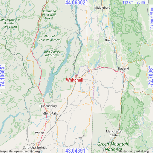
Whitehall GPS coordinates[2]
43° 33' 20.232" North, 73° 24' 13.392" West
| Map corner | latitude | longitude |
|---|---|---|
| Upper-left | 44.06302°, | -74.10685° |
| Center: | 43.55562°, | -73.40372° |
| Lower-right: | 43.04391°, | -72.7006° |
| Map W x H: | 113.3×113.3 km | = 70.4×70.4mi |
| max Lat: | 71.29058° ⇑13.4% North |
| Whitehall: | 43.55562° |
| min Lat: | ⇓86.6% South 19.06759° |
| min Long | Whitehall | max Long |
| -171.73463° | -73.40372° | -66.98998° |
| W 93%⇐ | ⇒7% E |
Elevation
Elevation of Whitehall is 45 m = 148 ft, and this is 249.8 m = 820 ft below average elevation for this country.
| Max E: |
3189 m = 10463 ft | 80.3% |
| Avg. | 294.8 m = 967 ft | |
| Whitehall | 45 m = 148 ft | |
Min E: |
-60 m = -197 ft | 19.7% |
See also: United States elevation on elevation.city.
Geographical zone
Whitehall is located in North temperate zone (between Tropic of Cancer and the Arctic Circle). Distance of this Northern Tropic circle is 2237 km =1390 mi to South.| Distance of | km | miles | from Whitehall |
|---|---|---|---|
| North Pole | 5164.1 | 3208.8 | to North |
| Arctic Circle | 2558.2 | 1589.6 | to North |
| Tropic Cancer | 2237 | 1390 | to South |
| Equator | 4842.9 | 3009.2 | to South |


Nearby cities:
15 places around Whitehall: (largest is in red/bold)
• Bolton Landing
20.2 km =12.6 mi,  270°
270°
• Castleton
19 km =11.8 mi,  71°
71°
• Fair Haven
11.9 km =7.4 mi, 68°
• Glens Falls North
33.3 km =20.7 mi,  222°
222°
• Granville
20.1 km =12.5 mi,  144°
144°
• Hampton
12.7 km =7.9 mi,  105°
105°
• Hartford
21.4 km =13.3 mi,  177°
177°
• Hudson Falls
31.9 km =19.8 mi,  207°
207°
• Lake George
28.8 km =17.9 mi,  239°
239°
• Pawlet
29.6 km =18.4 mi, 141°
• Poultney
14.2 km =8.8 mi, 107°
• Queensbury
26.1 km =16.2 mi, 220°
• Ticonderoga
32.6 km =20.3 mi,  357°
357°
• Warrensburg
30.7 km =19.1 mi,  257°
257°
• West Rutland
29.2 km =18.1 mi,  81°
81°
Sources, notices
• [Note1] Compared only with cities in United States existing in our database
• [Src1] Map data: © OpenStreetMap contributors (CC-BY-SA)
• [Src2] Other city data from geonames.org with taken over terms of usage.
• [Src3] Geographical zone / Annual Mean Temperature by Robert A. Rohde @ Wikipedia
