Anna geodata
Anna (Ohio) is a populated place; located in United States in America/New_York (GMT-4) time zone. With population of 1,545 people, there are 13490 cities with bigger population in this country. Compared to other cities in United States, 57.8% of cities are located further ↓South; 58.7% of cities are located further ←West and 75.1% of cities have lower elevation than Anna. Note1


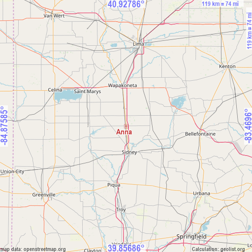
Anna GPS coordinates[2]
40° 23' 40.164" North, 84° 10' 21.792" West
| Map corner | latitude | longitude |
|---|---|---|
| Upper-left | 40.92786°, | -84.87585° |
| Center: | 40.39449°, | -84.17272° |
| Lower-right: | 39.85686°, | -83.4696° |
| Map W x H: | 119.1×119.1 km | = 74×74mi |
| max Lat: | 71.29058° ⇑42.2% North |
| Anna: | 40.39449° |
| min Lat: | ⇓57.8% South 19.06759° |
| min Long | Anna | max Long |
| -171.73463° | -84.17272° | -66.98998° |
| W 58.7%⇐ | ⇒41.3% E |
Elevation
Elevation of Anna is 314 m = 1030 ft, and this is 19.2 m = 63 ft above average elevation for this country.
| Max E: |
3189 m = 10463 ft | 24.9% |
| Anna | 314 m 1030 ft | |
| Avg. | 294.8 m = 967 ft | |
Min E: |
-60 m = -197 ft | 75.1% |
See also: United States elevation on elevation.city.
Geographical zone
Anna is located in North temperate zone (between Tropic of Cancer and the Arctic Circle). Distance of this Northern Tropic circle is 1885.5 km =1171.6 mi to South.| Distance of | km | miles | from Anna |
|---|---|---|---|
| North Pole | 5515.6 | 3427.2 | to North |
| Arctic Circle | 2909.7 | 1808 | to North |
| Tropic Cancer | 1885.5 | 1171.6 | to South |
| Equator | 4491.4 | 2790.8 | to South |


Nearby cities:
15 places around Anna: (largest is in red/bold)
• Botkins
8.2 km =5.1 mi,  355°
355°
• Chippewa Park
27.5 km =17.1 mi,  60°
60°
• De Graff
23.6 km =14.7 mi,  112°
112°
• Fort Loramie
17.7 km =11 mi,  254°
254°
• Jackson Center
12.3 km =7.6 mi,  65°
65°
• Lakeview
23.4 km =14.5 mi, 64°
• Minster
17.2 km =10.7 mi,  269°
269°
• New Bremen
18.1 km =11.2 mi,  285°
285°
• New Knoxville
16.3 km =10.1 mi,  312°
312°
• Quincy
20.3 km =12.6 mi,  121°
121°
• Russells Point
25.2 km =15.7 mi, 70°
• Russia
26.8 km =16.7 mi,  228°
228°
• Saint Marys
24.6 km =15.3 mi, 311°
• Sidney
12.3 km =7.6 mi,  173°
173°
• Wapakoneta
19.4 km =12.1 mi,  354°
354°
Sources, notices
• [Note1] Compared only with cities in United States existing in our database
• [Src1] Map data: © OpenStreetMap contributors (CC-BY-SA)
• [Src2] Other city data from geonames.org with taken over terms of usage.
• [Src3] Geographical zone / Annual Mean Temperature by Robert A. Rohde @ Wikipedia
