Warren geodata
Warren (Ohio) is a seat of a second-order administrative division; located in United States in America/New_York (GMT-4) time zone. With population of 40,245 people, there are 1204 cities with bigger population in this country. Compared to other cities in United States, 68.1% of cities are located further ↓South; 69.9% of cities are located further ←West and 67.8% of cities have lower elevation than Warren. Note1


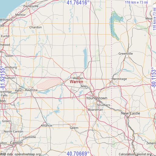
Warren GPS coordinates[2]
41° 14' 15.216" North, 80° 49' 6.312" West
| Map corner | latitude | longitude |
|---|---|---|
| Upper-left | 41.76416°, | -81.52155° |
| Center: | 41.23756°, | -80.81842° |
| Lower-right: | 40.70669°, | -80.1153° |
| Map W x H: | 117.6×117.6 km | = 73.1×73.1mi |
| max Lat: | 71.29058° ⇑31.9% North |
| Warren: | 41.23756° |
| min Lat: | ⇓68.1% South 19.06759° |
| min Long | Warren | max Long |
| -171.73463° | -80.81842° | -66.98998° |
| W 69.9%⇐ | ⇒30.1% E |
Elevation
Elevation of Warren is 275 m = 902 ft, and this is 19.8 m = 65 ft below average elevation for this country.
| Max E: |
3189 m = 10463 ft | 32.2% |
| Avg. | 294.8 m = 967 ft | |
| Warren | 275 m = 902 ft | |
Min E: |
-60 m = -197 ft | 67.8% |
See also: Warren elevation on elevation.city.
Geographical zone
Warren is located in North temperate zone (between Tropic of Cancer and the Arctic Circle). Distance of this Northern Tropic circle is 1979.3 km =1229.9 mi to South.| Distance of | km | miles | from Warren |
|---|---|---|---|
| North Pole | 5421.9 | 3369 | to North |
| Arctic Circle | 2816 | 1749.8 | to North |
| Tropic Cancer | 1979.3 | 1229.9 | to South |
| Equator | 4585.2 | 2849.1 | to South |


Nearby cities:
15 places around Warren: (largest is in red/bold)
• Bolindale
4.8 km =3 mi,  134°
134°
• Champion Heights
6.3 km =3.9 mi,  338°
338°
• Cortland
12.9 km =8 mi,  37°
37°
• Girard
13.5 km =8.4 mi, 133°
• Hilltop
10.7 km =6.6 mi,  140°
140°
• Howland Center
6.3 km =3.9 mi,  76°
76°
• Leavittsburg
5 km =3.1 mi,  283°
283°
• Lordstown
8.6 km =5.3 mi,  202°
202°
• McDonald
11.4 km =7.1 mi, 136°
• McKinley Heights
10.4 km =6.5 mi, 125°
• Mineral Ridge
11.6 km =7.2 mi,  159°
159°
• Morgandale
4.3 km =2.7 mi, 43°
• Newton Falls
14.4 km =8.9 mi,  247°
247°
• Niles
7.5 km =4.7 mi, 143°
• Vienna Center
12.3 km =7.6 mi, 83°
Sources, notices
• [Note1] Compared only with cities in United States existing in our database
• [Src1] Map data: © OpenStreetMap contributors (CC-BY-SA)
• [Src2] Other city data from geonames.org with taken over terms of usage.
• [Src3] Geographical zone / Annual Mean Temperature by Robert A. Rohde @ Wikipedia
