Yorkville geodata
Yorkville (Ohio) is a populated place; located in United States in America/New_York (GMT-4) time zone. With population of 1,044 people, there are 16001 cities with bigger population in this country. Compared to other cities in United States, 55.1% of cities are located further ↓South; 70.2% of cities are located further ←West and 50.2% of cities have lower elevation than Yorkville. Note1


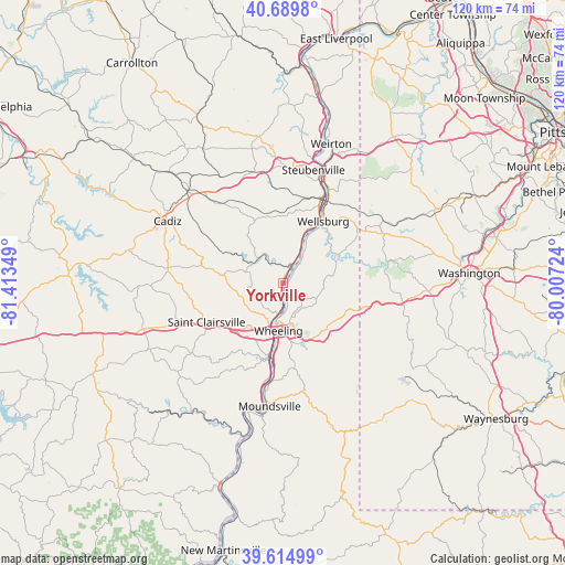
Yorkville GPS coordinates[2]
40° 9' 16.272" North, 80° 42' 37.296" West
| Map corner | latitude | longitude |
|---|---|---|
| Upper-left | 40.6898°, | -81.41349° |
| Center: | 40.15452°, | -80.71036° |
| Lower-right: | 39.61499°, | -80.00724° |
| Map W x H: | 119.5×119.5 km | = 74.3×74.3mi |
| max Lat: | 71.29058° ⇑44.9% North |
| Yorkville: | 40.15452° |
| min Lat: | ⇓55.1% South 19.06759° |
| min Long | Yorkville | max Long |
| -171.73463° | -80.71036° | -66.98998° |
| W 70.2%⇐ | ⇒29.8% E |
Elevation
Elevation of Yorkville is 199 m = 653 ft, and this is 95.8 m = 314 ft below average elevation for this country.
| Max E: |
3189 m = 10463 ft | 49.8% |
| Avg. | 294.8 m = 967 ft | |
| Yorkville | 199 m = 653 ft | |
Min E: |
-60 m = -197 ft | 50.2% |
See also: United States elevation on elevation.city.
Geographical zone
Yorkville is located in North temperate zone (between Tropic of Cancer and the Arctic Circle). Distance of this Northern Tropic circle is 1858.8 km =1155 mi to South.| Distance of | km | miles | from Yorkville |
|---|---|---|---|
| North Pole | 5542.3 | 3443.8 | to North |
| Arctic Circle | 2936.4 | 1824.6 | to North |
| Tropic Cancer | 1858.8 | 1155 | to South |
| Equator | 4464.8 | 2774.3 | to South |


Nearby cities:
15 places around Yorkville: (largest is in red/bold)
• Bethany
14.2 km =8.8 mi,  66°
66°
• Bethlehem
12.4 km =7.7 mi,  172°
172°
• Bridgeport
9.8 km =6.1 mi,  195°
195°
• Brilliant
14.2 km =8.8 mi,  30°
30°
• Brookside
10.3 km =6.4 mi, 204°
• Clearview
2.4 km =1.5 mi,  128°
128°
• Dillonvale
7.2 km =4.5 mi,  310°
310°
• Lansing
11.1 km =6.9 mi,  217°
217°
• Martins Ferry
6.6 km =4.1 mi,  190°
190°
• Smithfield
14.3 km =8.9 mi,  334°
334°
• Tiltonsville
1.6 km =1 mi, 33°
• Triadelphia
13.3 km =8.3 mi,  148°
148°
• West Liberty
10.1 km =6.3 mi,  80°
80°
• Wheeling
10.1 km =6.3 mi, 185°
• Wolfhurst
11.3 km =7 mi,  213°
213°
Sources, notices
• [Note1] Compared only with cities in United States existing in our database
• [Src1] Map data: © OpenStreetMap contributors (CC-BY-SA)
• [Src2] Other city data from geonames.org with taken over terms of usage.
• [Src3] Geographical zone / Annual Mean Temperature by Robert A. Rohde @ Wikipedia
