Albion geodata
Albion (Pennsylvania) is a populated place; located in United States in America/New_York (GMT-4) time zone. With population of 1,468 people, there are 13801 cities with bigger population in this country. Compared to other cities in United States, 74.7% of cities are located further ↓South; 71.4% of cities are located further ←West and 67.4% of cities have lower elevation than Albion. Note1


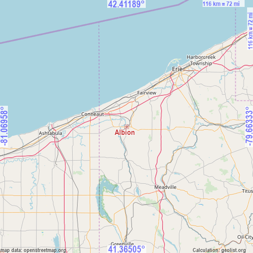
Albion GPS coordinates[2]
41° 53' 26.196" North, 80° 21' 59.22" West
| Map corner | latitude | longitude |
|---|---|---|
| Upper-left | 42.41189°, | -81.06958° |
| Center: | 41.89061°, | -80.36645° |
| Lower-right: | 41.36505°, | -79.66333° |
| Map W x H: | 116.4×116.4 km | = 72.3×72.3mi |
| max Lat: | 71.29058° ⇑25.3% North |
| Albion: | 41.89061° |
| min Lat: | ⇓74.7% South 19.06759° |
| min Long | Albion | max Long |
| -171.73463° | -80.36645° | -66.98998° |
| W 71.4%⇐ | ⇒28.6% E |
Elevation
Elevation of Albion is 273 m = 896 ft, and this is 21.8 m = 72 ft below average elevation for this country.
| Max E: |
3189 m = 10463 ft | 32.6% |
| Avg. | 294.8 m = 967 ft | |
| Albion | 273 m = 896 ft | |
Min E: |
-60 m = -197 ft | 67.4% |
See also: United States elevation on elevation.city.
Geographical zone
Albion is located in North temperate zone (between Tropic of Cancer and the Arctic Circle). Distance of this Northern Tropic circle is 2051.9 km =1275 mi to South.| Distance of | km | miles | from Albion |
|---|---|---|---|
| North Pole | 5349.3 | 3323.9 | to North |
| Arctic Circle | 2743.4 | 1704.7 | to North |
| Tropic Cancer | 2051.9 | 1275 | to South |
| Equator | 4657.8 | 2894.2 | to South |


Nearby cities:
15 places around Albion: (largest is in red/bold)
• Avonia
19 km =11.8 mi,  24°
24°
• Cambridge Springs
27.4 km =17 mi,  110°
110°
• Conneaut
16.8 km =10.4 mi,  292°
292°
• Conneaut Lakeshore
29.7 km =18.5 mi,  170°
170°
• Conneautville
14.8 km =9.2 mi,  180°
180°
• Cranesville
2.5 km =1.6 mi,  49°
49°
• Edinboro
19.5 km =12.1 mi,  95°
95°
• Fairview
18.2 km =11.3 mi,  30°
30°
• Fredericksburg
31.4 km =19.5 mi,  149°
149°
• Girard
12.8 km =8 mi, 18°
• Lake City
13.9 km =8.6 mi,  7°
7°
• Linesville
26.5 km =16.5 mi,  190°
190°
• North Kingsville
26.9 km =16.7 mi,  273°
273°
• Saegertown
26.3 km =16.3 mi,  136°
136°
• Waterford
32.1 km =19.9 mi,  79°
79°
Sources, notices
• [Note1] Compared only with cities in United States existing in our database
• [Src1] Map data: © OpenStreetMap contributors (CC-BY-SA)
• [Src2] Other city data from geonames.org with taken over terms of usage.
• [Src3] Geographical zone / Annual Mean Temperature by Robert A. Rohde @ Wikipedia
