Allentown geodata
Allentown (Pennsylvania) is a seat of a second-order administrative division; located in United States in America/New_York (GMT-4) time zone. With population of 120,207 people, there are 262 cities with bigger population in this country. Compared to other cities in United States, 60.2% of cities are located further ↓South; 85.7% of cities are located further ←West and 68.9% of cities have higher elevation than Allentown. Note1


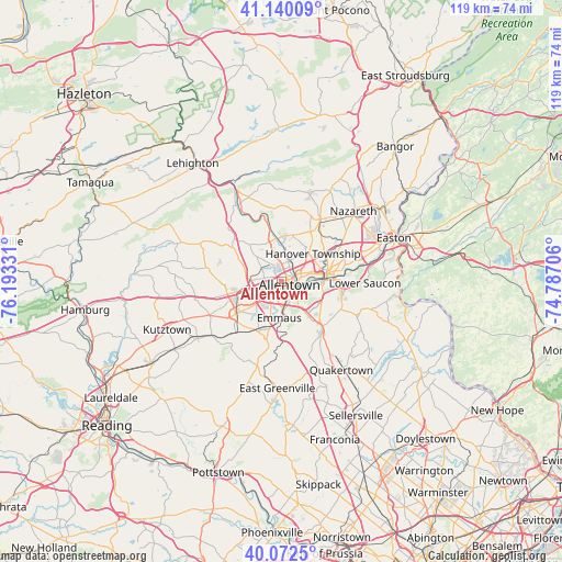
Allentown GPS coordinates[2]
40° 36' 30.348" North, 75° 29' 24.648" West
| Map corner | latitude | longitude |
|---|---|---|
| Upper-left | 41.14009°, | -76.19331° |
| Center: | 40.60843°, | -75.49018° |
| Lower-right: | 40.0725°, | -74.78706° |
| Map W x H: | 118.7×118.7 km | = 73.8×73.8mi |
| max Lat: | 71.29058° ⇑39.8% North |
| Allentown: | 40.60843° |
| min Lat: | ⇓60.2% South 19.06759° |
| min Long | Allentown | max Long |
| -171.73463° | -75.49018° | -66.98998° |
| W 85.7%⇐ | ⇒14.3% E |
Elevation
Elevation of Allentown is 107 m = 351 ft, and this is 187.8 m = 616 ft below average elevation for this country.
| Max E: |
3189 m = 10463 ft | 68.9% |
| Avg. | 294.8 m = 967 ft | |
| Allentown | 107 m = 351 ft | |
Min E: |
-60 m = -197 ft | 31.1% |
See also: Allentown elevation on elevation.city.
Geographical zone
Allentown is located in North temperate zone (between Tropic of Cancer and the Arctic Circle). Distance of this Northern Tropic circle is 1909.3 km =1186.4 mi to South.| Distance of | km | miles | from Allentown |
|---|---|---|---|
| North Pole | 5491.8 | 3412.4 | to North |
| Arctic Circle | 2885.9 | 1793.2 | to North |
| Tropic Cancer | 1909.3 | 1186.4 | to South |
| Equator | 4515.2 | 2805.6 | to South |


Nearby cities:
15 places around Allentown: (largest is in red/bold)
• Catasauqua
5.3 km =3.3 mi,  14°
14°
• Cementon
9.1 km =5.7 mi,  350°
350°
• Cetronia
4.1 km =2.5 mi,  234°
234°
• Coplay
6.9 km =4.3 mi,  356°
356°
• Dorneyville
4.5 km =2.8 mi,  213°
213°
• Egypt
8.6 km =5.3 mi,  337°
337°
• Emmaus
7.7 km =4.8 mi,  184°
184°
• Fountain Hill
8.1 km =5 mi,  95°
95°
• Fullerton
3 km =1.9 mi,  28°
28°
• Hokendauqua
6 km =3.7 mi, 359°
• North Catasauqua
5.8 km =3.6 mi, 11°
• Northampton
8.7 km =5.4 mi, 356°
• Stiles
6.5 km =4 mi, 346°
• Wescosville
7 km =4.3 mi, 228°
• Whitehall Township
6.5 km =4 mi, 352°
Sources, notices
• [Note1] Compared only with cities in United States existing in our database
• [Src1] Map data: © OpenStreetMap contributors (CC-BY-SA)
• [Src2] Other city data from geonames.org with taken over terms of usage.
• [Src3] Geographical zone / Annual Mean Temperature by Robert A. Rohde @ Wikipedia
