Cressona geodata
Cressona (Pennsylvania) is a populated place; located in United States in America/New_York (GMT-4) time zone. With population of 1,625 people, there are 13195 cities with bigger population in this country. Compared to other cities in United States, 60.4% of cities are located further ↓South; 83.5% of cities are located further ←West and 53.9% of cities have higher elevation than Cressona. Note1
Administrative division(s):
- Level 1: Pennsylvania
- Level 2: Schuylkill County
- Level 3: Borough of Cressona


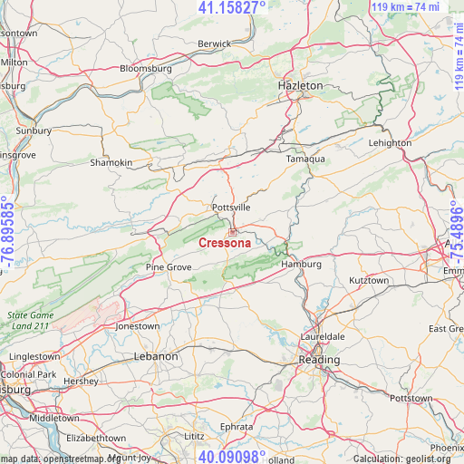
Cressona GPS coordinates[2]
40° 37' 36.336" North, 76° 11' 33.792" West
| Map corner | latitude | longitude |
|---|---|---|
| Upper-left | 41.15827°, | -76.89585° |
| Center: | 40.62676°, | -76.19272° |
| Lower-right: | 40.09098°, | -75.4896° |
| Map W x H: | 118.7×118.7 km | = 73.8×73.8mi |
| max Lat: | 71.29058° ⇑39.6% North |
| Cressona: | 40.62676° |
| min Lat: | ⇓60.4% South 19.06759° |
| min Long | Cressona | max Long |
| -171.73463° | -76.19272° | -66.98998° |
| W 83.5%⇐ | ⇒16.5% E |
Elevation
Elevation of Cressona is 184 m = 604 ft, and this is 110.8 m = 364 ft below average elevation for this country.
| Max E: |
3189 m = 10463 ft | 53.9% |
| Avg. | 294.8 m = 967 ft | |
| Cressona | 184 m = 604 ft | |
Min E: |
-60 m = -197 ft | 46.1% |
See also: United States elevation on elevation.city.
Geographical zone
Cressona is located in North temperate zone (between Tropic of Cancer and the Arctic Circle). Distance of this Northern Tropic circle is 1911.4 km =1187.7 mi to South.| Distance of | km | miles | from Cressona |
|---|---|---|---|
| North Pole | 5489.8 | 3411.2 | to North |
| Arctic Circle | 2883.9 | 1792 | to North |
| Tropic Cancer | 1911.4 | 1187.7 | to South |
| Equator | 4517.3 | 2806.9 | to South |


Nearby cities:
15 places around Cressona: (largest is in red/bold)
• Auburn
9 km =5.6 mi,  110°
110°
• Deer Lake
11.2 km =7 mi,  90°
90°
• Friedensburg
4.9 km =3 mi,  236°
236°
• Lake Wynonah
3.9 km =2.4 mi,  141°
141°
• Marlin
7.3 km =4.5 mi,  322°
322°
• Minersville
9.2 km =5.7 mi, 320°
• New Philadelphia
12.2 km =7.6 mi,  32°
32°
• Orwigsburg
8.4 km =5.2 mi,  68°
68°
• Palo Alto
7 km =4.3 mi,  14°
14°
• Port Carbon
8 km =5 mi, 14°
• Pottsville
6.6 km =4.1 mi,  357°
357°
• Renningers
4.6 km =2.9 mi,  55°
55°
• Saint Clair
10.4 km =6.5 mi,  0°
0°
• Schuylkill Haven
1.9 km =1.2 mi,  76°
76°
• Tremont
16.4 km =10.2 mi,  270°
270°
Sources, notices
• [Note1] Compared only with cities in United States existing in our database
• [Src1] Map data: © OpenStreetMap contributors (CC-BY-SA)
• [Src2] Other city data from geonames.org with taken over terms of usage.
• [Src3] Geographical zone / Annual Mean Temperature by Robert A. Rohde @ Wikipedia
