Dravosburg geodata
Dravosburg (Pennsylvania) is a populated place; located in United States in America/New_York (GMT-4) time zone. With population of 1,763 people, there are 12688 cities with bigger population in this country. Compared to other cities in United States, 57.3% of cities are located further ↓South; 73.8% of cities are located further ←West and 56.9% of cities have lower elevation than Dravosburg. Note1
Administrative division(s):
- Level 1: Pennsylvania
- Level 2: Allegheny County
- Level 3: Borough of Dravosburg


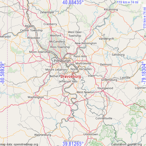
Dravosburg GPS coordinates[2]
40° 21' 2.268" North, 79° 53' 10.176" West
| Map corner | latitude | longitude |
|---|---|---|
| Upper-left | 40.88435°, | -80.58929° |
| Center: | 40.35063°, | -79.88616° |
| Lower-right: | 39.81265°, | -79.18304° |
| Map W x H: | 119.2×119.2 km | = 74.1×74.1mi |
| max Lat: | 71.29058° ⇑42.7% North |
| Dravosburg: | 40.35063° |
| min Lat: | ⇓57.3% South 19.06759° |
| min Long | Dravosburg | max Long |
| -171.73463° | -79.88616° | -66.98998° |
| W 73.8%⇐ | ⇒26.2% E |
Elevation
Elevation of Dravosburg is 226 m = 741 ft, and this is 68.8 m = 226 ft below average elevation for this country.
| Max E: |
3189 m = 10463 ft | 43.1% |
| Avg. | 294.8 m = 967 ft | |
| Dravosburg | 226 m = 741 ft | |
Min E: |
-60 m = -197 ft | 56.9% |
See also: United States elevation on elevation.city.
Geographical zone
Dravosburg is located in North temperate zone (between Tropic of Cancer and the Arctic Circle). Distance of this Northern Tropic circle is 1880.7 km =1168.6 mi to South.| Distance of | km | miles | from Dravosburg |
|---|---|---|---|
| North Pole | 5520.5 | 3430.3 | to North |
| Arctic Circle | 2914.6 | 1811 | to North |
| Tropic Cancer | 1880.7 | 1168.6 | to South |
| Equator | 4486.6 | 2787.8 | to South |


Nearby cities:
15 places around Dravosburg: (largest is in red/bold)
• Braddock
6.1 km =3.8 mi,  14°
14°
• Clairton
6.5 km =4 mi,  176°
176°
• Duquesne
4.1 km =2.5 mi,  33°
33°
• East Pittsburgh
6.4 km =4 mi,  38°
38°
• Glassport
2.9 km =1.8 mi,  190°
190°
• Liberty
3.8 km =2.4 mi,  137°
137°
• Lincoln
4.4 km =2.7 mi, 142°
• McKeesport
1.9 km =1.2 mi,  99°
99°
• Munhall
4.8 km =3 mi,  345°
345°
• Port Vue
2.1 km =1.3 mi, 139°
• Versailles
6.1 km =3.8 mi,  129°
129°
• West Homestead
5.3 km =3.3 mi,  335°
335°
• West Mifflin
2.2 km =1.4 mi,  49°
49°
• Whitaker
5.3 km =3.3 mi,  356°
356°
• Wilson
4.5 km =2.8 mi, 185°
Sources, notices
• [Note1] Compared only with cities in United States existing in our database
• [Src1] Map data: © OpenStreetMap contributors (CC-BY-SA)
• [Src2] Other city data from geonames.org with taken over terms of usage.
• [Src3] Geographical zone / Annual Mean Temperature by Robert A. Rohde @ Wikipedia
